
Voice of the Earth and Space Science Community
This blog Site
21 August 2019
The Kavalappara landslide in the western Ghats of India
Posted by Dave Petley
At 7:30 pm on 8th August 2019 the large the Kavalappara landslide in Wayanad, part of the western Ghats in Kerala, India buried a small community. Whilst rescue operations continue, it has been reported that 46 bodies have been recovered from the debris, whilst it is believed that a further 13 people were killed. The landslide was triggered by a period of intense monsoon rainfall. The Indian Express has some details about the precipitation event that initiated the landslide :
Malappuram meteorological subdivision got 189.4 mm rain from August 1 to August 7, 66% more than the normal 114.3 mm. On August 8, the Nilambur rain gauge station, the one nearest to Kavalappara, recorded the highest rainfall of that day in Kerala.
Indian Express also has this image of the landslide, which appears to have been both large and mobile:-

The 8th August 2019 The Kavalappara landslide, which killed 59 people. Image via the Indian Express .
Meanwhile, t he Deccan Chronicle has a different perspective on the landslide:-

The 8th August 2019 Kavalappara landslide in the Western Ghats of India. Image via the Deccan Chronicle .
The deep red soils indicate a high degree of weathering. The upper quarter of the landslide source appears to have exposed bedrock, perhaps suggesting that the initial failure occurred on the interface between weathered and intact rock. This portion of the slide surface appears to be much steeper than the rest of the landslide source. The lower three-quarters of the landslide source appear to be situated in weathered soils or regolith. Note that the flow bifurcated into three streams, presumably controlled by the underlying topography. This has left an undisturbed island of trees, which is reminiscent of the Pingdi landslide in China that I highlighted yesterday . The other flow path has cut a separate track.
The heavy rainfall that triggered this landslide caused widespread damage. At Puthumala, also within Wayanad district, 17 people were killed when 53 houses, a mosque, a temple and a shop were buried by another large landslide.
Posted in: landslide report 6 Comments/Trackbacks »
Thank you for the information
Landslide are being an unavoidable part these years in Kerala. In August 2020, Pettimudi-Rajamala, Idukki district of Western Ghats witnessed another massive landslide where more than 50 lives lost. Being a Geoscientist it’s our need to find out exact reasons and remedies to prevent it so that atleast we could save more lives. Expecting AGU’s kind attention on this regard.
The landslide actually took place in the Malappuram District of Kerala, not Wayanad District.
Where is kavalappara ? Malappuram or wayanad
Leave a Reply Cancel reply
Your email address will not be published. Required fields are marked *
Save my name, email, and website in this browser for the next time I comment.
Subscribe to the Landslide Blog
Ideas and opinions expressed on this site are those of the authors and commenters alone. they do not necessarily represent the views of the american geophysical union..
- Durham University Tipping Points project
- The Institute of Hazard, Risk and Resilience Blog
- Dan's Wild Wild Science Journal >>
- Editors' Vox >>
- From The Prow >>
- From a Glacier's Perspective >>
- GeoEd Trek >>
- Georneys >>
- Magma Cum Laude >>
- Martian Chronicles >>
- Mountain Beltway >>
- On the Job >>
- Terra Central >>
- The Bridge: Connecting Science and Policy >>
- The Field >>
- The Landslide Blog >>
- The Plainspoken Scientist >>
- The Trembling Earth >>
- Third Pod from the Sun >>
- Thriving Earth Exchange >>
- Water Underground >>
Recent Posts
- A new home for the Landslide Blog
- A very lucky escape in a debris flow in Arunachal Pradesh, northern India
- Bisisthal: a one million tonne rock slope collapse in Switzerland
- Two new mudflow videos
- The location of the 20 July 2023 debris flow at Ungar in Lhuentse, Bhutan
Most Popular Posts
- The Canterbury Earthquake: Images of the distorted railway line (76)
- Killing off the Canary Islands landslide megatsunami scare (59)
- Liquefaction from the Sendai earthquake - a remarkable video (55)
- Rattlesnake Ridge: a large failure forming in Washington State, USA (49)
- Bento Rodrigues: a disastrous tailings dam failure in Brazil (39)
Recent Comments
- John Farthing on My latest paper: Patterns of movement at the Ventnor landslide on the Isle of Wight
- Possible causes of the deadly 21 June 2024 Sorte debris flow – The Insight Post on Debris flow video from Hong Kong
- Liz on My latest paper: Patterns of movement at the Ventnor landslide on the Isle of Wight
- John Blomenberg on The 1954 Prospect Point Rockfall at Niagara Falls
- Miller on A small but interesting landslide at Park City in Utah, USA
- Contact AGU
- Terms of Use
- Privacy Policy
- Brief Report
- Open access
- Published: 13 July 2022
The tale of three landslides in the Western Ghats, India: lessons to be learnt
- R. S. Ajin 1 ,
- D. Nandakumar 2 ,
- A. Rajaneesh 3 ,
- T. Oommen 4 ,
- Yunus P. Ali 5 &
- K. S. Sajinkumar 3
Geoenvironmental Disasters volume 9 , Article number: 16 ( 2022 ) Cite this article
9107 Accesses
18 Citations
12 Altmetric
Metrics details
In recent years, landslides have become a typical monsoon calamity in the Western Ghats region of Kerala, India. In addition to property damage, heavy rainfall (36% above normal) and multiple landslides (4728) killed 48 people in 2018. This tendency continued throughout the monsoon seasons of 2019, 2020, and 2021, resulting in the deaths of over 100 people. Anomalous precipitation is ascribed to the frequent development of low-pressure in the surrounding oceans. Using ground real data and satellite imagery, we evaluated the features of three large landslides in the state of Kerala, which occurred during the monsoon season of 2021. Our investigation found that the Kokkayar landslide was triggered by anthropogenic-related agricultural activities, the Plappally landslide by geomorphic and tectonic processes as well as human involvement, and the Kavali landslide by forest fragmentation with dense vegetation on thin soil. The triggering mechanism for all three of these landslides, however, is the intense rainfall of 266 mm in less than 24 h. Thus, an accurate and precise forecast of rainfall can be used to define a threshold for an early warning, which will be vital for saving lives.
Introduction
Catastrophic landslides have become a common monsoonal phenomenon in India’s southwest state of Kerala, which is located in the foothills of the prominent mountain chain, the Western Ghats. The anomalous rainfall of 2018, which was about 36% more than the normal rainfall (Vishnu et al. 2019 ), triggered 4728 landslides (Hao et al. 2020 ) and killed 48 people. These landslides occurred in a single storm-event i.e., 16th August 2018. The following years saw further landslides, with the monsoon season of 2019 witnessing disastrous landslides such as the one at Puthumala, which killed 17 people, and the Kavalappara, which killed another 59 people (Sajinkumar and Oommen 2020 ; Wadhawan et al. 2020 ). Both these landslides occurred on 8th August 2019. The Pettimudi landslide of 6th August 2020 was the most tragic one that killed 70 people and devastated several hutments in a tea plantation region (Achu et al. 2021 ; Sajinkumar and Oommen 2021 ). Year 2021 also experienced cataclysmic landslides on 16th October with the most disastrous ones being at Kokkayar in Idukki district and Plappally and Kavali, near Koottickal in Kottayam district. All these devastating landslides that occurred since 2018 showed an uneven geographic distribution (Fig. 1 a, b), pointing to the possibility that many parts of the Western Ghats are susceptible to landslides, though these landslides are located along the same valley (Fig. 1 c). In this study, we narrate the ground real data and interpretation of high-resolution remotely sensed images of the three landslides- Kokkayar, Plappally and Kavali (Fig. 2 , a, b, c) that occurred in 2021. We also employed ethnographic techniques, such as in-depth interviews with elderly impacted individuals, to learn about their shared experiences. These three landslides are amongst the tens of landslides in the vicinity of the study area (Fig. 3 ). The reason for selecting these three landslides is because of their catastrophic nature resulting in many human casualties. We believe that the narrative of these three landslides applies to other landslides that occurred in the immediate vicinity of this area.

(Source: Google Earth) ( b ) Study area with elevation map draped over hill shade map showing major landslides since 2018 (Elevation data is ALOS PALSAR) ( c ) Google Earth image showing the spatial distribution of these three landslides along a valley
Location map ( a ) South India

Field photos of ( a ) Kokkayar landslide ( b ) Plappally landslide ( c ) Kavali landslide

A distant view of the hills in the study area showing several landslides
Site and situation of the landslides
Kokkayar landslide.
Kokkayar landslide (9°34′21''N; 76°53′13''E) of Peermade taluk in the Idukki district of Kerala has killed seven people and completely destroyed seven houses. The dimension of this landslide is 500 m (length) × 40 m (avg. width) × 1 m (avg. thickness). Rubber plantations predominantly occupy the area with intermittent clusters of mixed vegetation. The area is utilized for agriculture through terrace cultivation with the cut slope protected by rubble masonry wall. Rain pits were constructed on this slope. Houses are constructed by the cut and fill method but without any support in the cut slope. Most of the houses have dug wells and the depth to water level is shallow (< 2 m) whereas during the landslide these were found overflowing (as per local witness), pointing to the fully saturated column of soil. Numerous springs spout from this area (Fig. 4 a). This spouting phenomenon existed before landslides because dwellings have drains to flush away storm water (Fig. 4 b). These observations indicate that a seasonal first and/or second-order stream flows through this area, which might have been modified during the course of agriculture and/or habitation. A few fresh gullies have been formed, to which water is now confined.

a Spouting of spring at Kokkayar landslide ( b ) A demolished house having provisions for draining storm water ( c ) A highly-weathered joint in the country hornblende biotite gneiss ( d ) Soil profile showing dislodged material, lateritic soil, saprock and weathered bedrock
The in-depth interviews with the local people revealed that the vegetation, mainly rubber trees were clear-felled after slaughter tapping a few years prior to the event. Contour bunding and rain-pits were made prior to replanting the rubber saplings. These interventions seem to have taken place ignoring the natural hydrological requirement of letting the first/second order streams to have its free flow channels. Such interventions may have contributed to destabilizing of soil on the slopes.
The area is characterized by outcrops of hornblende biotite gneiss. The general trend of this foliated rock is 173°/35 W. The preponderance of feldspar in this rock and its subsequent alteration through weathering has resulted in the formation of clay. The rock is highly jointed, and weathering is found to be extensive along these joints (Fig. 4 c). The crown of the landslide is occupied by bouldery outcrops of this rock with no soil cover. Hence, during monsoon, all the water in the crown part has surcharged the immediately downslope column of lateritic soil causing an increase in pore-water pressure. Near the flanks of the landslide, the soil profile shows dislodged soil followed by lateritic soil of 1 m thickness and another 1 m thick saprolite (Fig. 4 d). This is further followed by bedrock. The dislodged material was finally dumped into the Pullakayar, a tributary of Manimala River.
Plappally landslide
Plappally landslide (9°37′3''N; 76°52′21''E) in Kanjirapally taluk of Kottayam district has killed four people and demolished two buildings. This landslide of 500 m (length) × 20 (avg. width) × 1 m (avg. thickness) was initiated in a rubber plantation whereas its runout stretches through areas of different land use types. In the Google Earth image (before landslide), the upslope in which the landslide occurred is confined is a truncated spur and its right boundary is marked by a straight lower-order river course, indicating a lineament (Fig. 5 a). Due to the broader surface area of this spur, the run-off zone is more extensive. The storm water when crossing the barren rock outcrop, situated downslope, facilitates sudden surcharge to the thin veneer of soil lying immediately downslope. It is in this zone the recent landslide was initiated. The surcharge zone can be well seen in the high-resolution (3 m) False Colour Composite (FCC) of Planet Lab (Fig. 5 b). The truncated spur together with the bulged foothill suggests this as a paleo-landslide, within which the recent landslide occurred.

a Google Earth image showing a distant view of Plappally landslide showing a suspected lineament, remnants of paleolandslide and its associated truncated spur ( b ) 3 m resolution FCC of Planet Lab image showing the landslide runout and its surcharge area ( c ) Storm water gushing through the uprooted house location ( d ) The ruins of the devastated house, which was constructed along the course of a lower-order stream ( e ) Seepage along the joints of hornblende biotite gneiss
This landslide is also confined to a lower-order stream course. The two buildings, which were destroyed, were constructed precisely on the river course. Water gushes through this during the monsoon (Fig. 5 c), whereas it is dry during the non-monsoon season (Fig. 5 d) showing its seasonal nature. But seepage can be seen along the joints of the country rock, hornblende biotite gneiss (Fig. 5 e). Here again, in the upper slope, where the houses stood before the landslide, plantation with young rubber trees existed, which indicates a similar influencing factor like at Kokkayar.
Kavali landslide
Six people died and one house was demolished by the Kavali landslide, which is 250 m (length) × 15 (avg. width) × 2 m (avg. thickness) in dimension. Hornblende biotite gneiss is the country rock, which is highly weathered and jointed. The attitude of this highly foliated rock is 315°/80NE. Here too, spring water is tapped for domestic purposes. The destroyed house was constructed in a cut-slope, but the cut-slope is still retained after the landslide. The cut-slope profile exhibits lateritic soil, saprolite, and weathered bedrock. The area is characterized by thick vegetation when compared to the sparse vegetation in the adjacent area. This thick mixed vegetation with rubber plantation is the major crop, followed by nutmeg, arecanut, and teak. Google Earth image (Fig. 6 a) also revealed thick vegetation. A Normalized Difference Vegetation Index (NDVI) map was created using the high-resolution Planet Lab image to understand the area’s land use. NDVI revealed that the landslide occurred in a densely vegetated area when compared to other areas consisting of a wide variety of land uses like moderate vegetation, grassland, barren outcrop, and built-up. Usually, landslides are less reported in densely vegetated areas (cf. Alcantara-Ayala et al. 2006 ; Reichenbach et al. 2014 ). In contrast to this, a recent study by Lan et al. ( 2020 ) suggests that a densely vegetated slope decreases its stability. This study has been concurred with by the recent findings of Hao et al. ( 2022 ) wherein most of the landslides that occurred in Kerala during 2018 are spatially associated with forest land. However, a closer look at Fig. 6 a, b reveals forest fragmentation and breaking-off of the contiguity of the forest canopy, creating scattered and fragmented forest islands. Studies reveal that such a process could compromise landscape integrity (Ramachandra and Kumar 2011 ; Batar et al. 2021 ).

a Google Earth image showing a distant view of Kavali landslide and forest fragmentation ( b ) NDVI of Kavali area depicting dense vegetation in landslide occurred area
The Western Ghats, especially its southern part encompassing the entire state of Kerala, witness landslides often during monsoon season. Since 2018, the noteworthy feature of the monsoon has been that it triggers landslides during the sporadic high-intensity rainfall (cf. Vishnu et al. 2019 , 2020 ; Yunus et al. 2021 ; Sajinkumar et al. 2022 ). Though several studies have been conducted in this region, and measures suggested were not adopted, we present here specific omnipresent reasons that facilitate landslides in this region.
Introspection of land use policy
The recent landslide susceptibility map of Kerala (cf. Sajinkumar and Oommen 2021 ; Escobar-Wolf et al. 2021 ) shows an area of 3300 and 2886 km 2 as highly and moderately susceptible to landslides, respectively. It will be an arduous task to implement stringent measures such as habitation- and construction-free zones in these areas. However, some of the landslide-facilitating practices that are common, may be inadvertently so, can be averted. Kerala is predominantly an agrarian state, and the general agricultural land use seen are cash crops, with rubber plantations occupying the midlands and tea, coffee and cardamom in the highlands. All the three landslides occurred in the midlands, especially where rubber plantation dominates the land use. The construction of rain pits is a common practice in almost all rubber estates. Major disturbance to the slope stability occurs when fully matured rubber trees are slaughtered after their life span of ~ 20 years, and fresh saplings are planted in a broad pit of 1 m 3 size. Rain pits are also dug here. The method of stubble mulching is not practiced here and large area of land will be disturbed when the trees are uprooted using machinery. Hence, avoiding rain pits, planting pits, and promoting stubble mulching practice will help reduce the probability of landslide occurrences. Avoiding rain pits and planting pits in susceptible landslide areas will help increase run-off rather than infiltration. In addition, all agricultural techniques on the hilly slope affects the lower-order drainage, by obstructing it with rubble-masonry walls, redirecting it to a more hazardous slope, or by constructing houses. These lower-order courses, except in thickly vegetated forest areas, are usually seasonal, and during monsoon season, the normal flow of water is thus disturbed by these practices. Hence, a stringent land use policy to avoid such practices in agricultural fields is a pressing requirement.
Rainfall- the sole triggering factor
As mentioned, these three landslides were also triggered by a sporadic-high intensity rainfall of > 266 mm in a single day (Fig. 7 ) but with a 5-day antecedent rainfall of only 109.9 mm. The comparatively higher rainfall of 48.8 (2nd October), 45.4 (8th October and 69.6 mm (11th October) might have saturated the soil column and the 16th October anomalous event was sufficient enough to trigger landslides. In order to limit the risk of rainfall-induced landslides, an accurate and exact rainfall forecast that allows for the issuance of early warnings based on the rainfall threshold of the area is essential (Weidner et al. 2018 ). The sparse density of rain gauges and manual operation methods make things difficult. For e.g., the rain gauge station nearest to these three landslides is Kanjirapally, approximately 10 km away from this landslide, which is grossly inadequate to capture the micro-climatic conditions of the susceptible areas. Moreover, this rain gauge station is a manual one with daily rainfall recording on the succeeding day at 8.30 am ( www.imd.gov.in ). Having automated rain gauges that report rain information near real-time will be critical for developing early warning systems.

Hyetograph of Kanjirappally rain gauge, which is the nearest to the landslide affected area. Note the prominent 266 mm rainfall on the landslide day
Soil thickness and soil-rock interface plane
The hilly area of the entire state of Kerala is characterized by a thin veneer of unconsolidated soil, resting above the massive Precambrian crystalline rock except for plateau regions like Munnar and Nelliyampathy (Sajinkumar and Anbazhagan 2015 ). Usually, the glide plane of the landslides will be the contact plane of these two litho-units (cf. Istiyanti et al. 2021 ). Thus, wherever the landslide occurs, the bedrock will be exposed, which can be seen in all these three landslides. Hence, along with the understanding of landslide susceptibility, the soil thickness of the area and the saturation capacity of that soil column have to be investigated. The contact between these two litho-units is stable in a plain or gentler slope (Fig. 8 a) whereas it will be in a meta-stable position when in a steep slope (cf. Getachew and Meten 2021 ; Puente-Sotomayor et al. 2021 ) (Fig. 8 b). This equilibrium will be lost when the soil column is saturated by water during the monsoon season (Fig. 8 c).

Sketch depicting the contact between unconsolidated soil and massive crystalline Precambrian rocks along the Western Ghats part of Kerala. ( a–c ) shows the different stages of stability of these two lithounits
The three landslides that occurred on 16th October 2021 are located in the same valley, and were triggered by a high-intensity rainfall of 266 mm in one day. These similarities are never the same when conditioning factors are analyzed. The steep slopes of the hilly regions where all three landslides occurred originally contained natural contiguous forests that may have held the thin soil and regolith layer together. The modern landscape, however, is dominated by human interventions such as the replacement of natural vegetation with plantations, highways, and human settlements. These measures facilitated the triggering of the landslides by a sudden storm of intense rainfall (cf. Lahai et al. 2021 ). However, a closer check using ground reality and satellite photographs revealed that the Kokkayar landslide was completely caused by humans, whereas the Plappally landslide was also affected by geomorphic and tectonic causes. The third site, the Kavali landslide, was caused by forest fragmentation on the forest island. Consequently, regardless of the contributing components, the common and vital feature to be researched is the rainfall dynamics, which can be converted into early warning systems, thereby saving countless lives.
Achu AL, Joseph S, Aju CD, Mathai J (2021) Preliminary analysis of a catastrophic landslide event at Pettimudi, Kerala state. India Landslides 18:1459–1463
Article Google Scholar
Alcántara-Ayala I, Esteban-Chávez O, Parrot JF (2006) Landsliding related to land-cover change: a diachronic analysis of hillslope instability distribution in the Sierra Norte, Puebla, Mexico. CATENA 65:152–165
Batar AK, Shibata H, Watanabe T (2021) A novel approach for forest fragmentation susceptibility mapping and assessment: a case study from the Indian Himalayan region. Remote Sens 13(20):4090
Escobar-Wolf RV, Sanders JD, Oommen T, Sajinkumar KS, Vishnu CL (2021) A GIS tool for infinite slope stability analysis (GIS-TISSA). Geosci Front 12(2):756–768
Getachew N, Meten M (2021) Weights of evidence modeling for landslide susceptibility mapping of Kabi-Gebro locality, Gundomeskel area central Ethiopia. Geoenviron Disasters 8(1):1–22
Hao L, Rajaneesh A, van Westen C, Sajinkumar KS, Martha TR, Jaiswal P, McAdoo BG (2020) Constructing a complete landslide inventory dataset for the 2018 Monsoon disaster in Kerala, India, for land use change analysis. Earth Syst Sci Data 12(4):2899–2918
Hao L, van Westen C, Rajaneesh A, Sajinkumar KS, Martha TR, Jaiswal P (2022) Evaluating the relation between land use changes and the 2018 landslide disaster in Kerala, India, for land use change analysis. CATENA 216:106363
Istiyanti ML, Goto S, Ochiai H (2021) Characteristics of tuff breccia-andesite in diverse mechanisms of landslides in Oita Prefecture, Kyushu Japan. Geoenviron Disasters 8(1):1–14
Lahai YA, Anderson KF, Jalloh Y, Rogers I, Kamara M (2021) A comparative geological, tectonic and geomorphological assessment of the Charlotte, Regent and Madina landslides, Western area Sierra Leone. Geoenviron Disasters 8(1):1–17
Lan H, Wang D, He S, Fang Y, Chen W, Zhao P, Qi Y (2020) Experimental study on the effects of tree planting on slope stability. Landslides 17:1021–1035
Puente-Sotomayor F, Mustafa A, Teller J (2021) Landslide susceptibility mapping of urban areas: logistic regression and sensitivity analysis applied to quito Ecuador. Geoenviron Disasters 8(1):1–26
Ramachandra T, Kumar U (2011) Characterisation of landscape with forest fragmentation dynamics. J Geogr Inf Syst 3(3):242–253
Google Scholar
Reichenbach P, Busca C, Mondini AC, Rossi M (2014) The influence of land use change on landslide susceptibility zonation: the Briga catchment test site (Messina, Italy). Environ Manage 54:1372–1384
Article CAS Google Scholar
Sajinkumar KS, Anbazhagan S (2015) Geomorphic appraisal of landslides on the windward slope of Western Ghats, southern India. Nat Hazards 75(1):953–973
Sajinkumar KS, Oommen T (2020) Rajamala landslide: continuation of a never-ending landslides series. J Geol Soc India 6:310
Sajinkumar KS, Arya A, Rajaneesh A, Oommen T, Ali P, Yunus RVR, Avatar R, Thrivikramji KP (2022) Migrating rivers, consequent paleochannels: the unlikely partners and hotspots of flooding. Sci Total Environ 807:150842
Sajinkumar KS, Oommen T (2021) Landslide atlas of Kerala. Geol Soc India, p 34.
Vishnu CL, Sajinkumar KS, Oommen T, Coffman RA, Thrivikramji K, Rani VR, Keerthy S (2019) Satellite-based assessment of the August 2018 flood in parts of Kerala, India. Geomat Nat Hazards Risk 10(1):758–767
Vishnu CL, Rani VR, Sajinkumar KS, Oommen T, Bonali FL, Pareeth S, Thrivikramji K, McAdoo BG, Anilkumar Y (2020) Catastrophic flood of August 2018, Kerala, India: partitioning role of geologic factors in modulating flood level using remote sensing data. Remote Sens Appl Soc Environ 2:100426
Wadhawan SK, Singh B, Ramesh MV (2020) Causative factors of landslides 2019: case study in Malappuram and Wayanad districts of Kerala. India Landslides 17:2689–2697
Weidner L, Oommen T, Escobar-Wolf RV, Sajinkumar KS, Rinu S (2018) Regional scale back-analysis using TRIGRS: An approach to advance landslide hazard modeling and prediction in sparse data regions. Landslides 15(12):2343–2356
Yunus AP, Fan X, Subramanian SS, Jie D, Xu Q (2021) Unraveling the drivers of intensified landslide regimes in Western Ghats, India. Sci Total Environ 770:145357
Download references
Acknowledgements
The authors thank Kerala State Disaster Management Authority (KSDMA) for facilitating fieldwork in these areas. Jobin Sebastian, a freelance photographer and paraglide trainer, is highly thanked for providing photos (Figs. 1 d and 2 ). The lab work was carried out at the Laboratory for Earth Resources Information System (LERIS) housed at the Department of Geology, University of Kerala. LERIS is a collaborative initiative of Indian Space Research Organization and University of Kerala.
The author declare that there is no funding in the manuscript.
Author information
Authors and affiliations.
State Emergency Operations Centre, Kerala State Disaster Management Authority (KSDMA), Thiruvananthapuram, Kerala, 695033, India
Sree Sankaracharya University of Sanskrit, Kalady, Kerala, 683574, India
D. Nandakumar
Department of Geology, University of Kerala, Thiruvananthapuram, Kerala, 695581, India
A. Rajaneesh & K. S. Sajinkumar
Department of Geological and Mining Engineering and Sciences, Michigan Technological University, Houghton, MI, 49931, USA
Indian Institute of Science Education and Research, Mohali, Punjab, 140306, India
Yunus P. Ali
You can also search for this author in PubMed Google Scholar
Contributions
RSA-Field visit, manuscript writing DN-Field visit, manuscript writing AR-Data analysis, figure preparation TO-Data analysis, figure preparation, manuscript writing YPA-Data analysis, figure preparation, manuscript writing KSS-Field visit, Data analysis, figure preparation, manuscript writing, supervision
Corresponding author
Correspondence to K. S. Sajinkumar .
Ethics declarations
Ethical approval.
The data employed in this work is accessible to the public upon request and therefore ethical approval is not required. This paper is not being submitted to any other journal at the same time.
Competing interests
The authors declare that we have no financial and personal relationships with other people or organizations that can inappropriately influence our work, there is no professional or other personal interest of any nature or kind in any product, service, and/or company that could be construed as influencing the position presented in, or the review.
Additional information
Publisher's note.
Springer Nature remains neutral with regard to jurisdictional claims in published maps and institutional affiliations.
Rights and permissions
Open Access This article is licensed under a Creative Commons Attribution 4.0 International License, which permits use, sharing, adaptation, distribution and reproduction in any medium or format, as long as you give appropriate credit to the original author(s) and the source, provide a link to the Creative Commons licence, and indicate if changes were made. The images or other third party material in this article are included in the article's Creative Commons licence, unless indicated otherwise in a credit line to the material. If material is not included in the article's Creative Commons licence and your intended use is not permitted by statutory regulation or exceeds the permitted use, you will need to obtain permission directly from the copyright holder. To view a copy of this licence, visit http://creativecommons.org/licenses/by/4.0/ .
Reprints and permissions
About this article
Cite this article.
Ajin, R.S., Nandakumar, D., Rajaneesh, A. et al. The tale of three landslides in the Western Ghats, India: lessons to be learnt. Geoenviron Disasters 9 , 16 (2022). https://doi.org/10.1186/s40677-022-00218-1
Download citation
Received : 13 February 2022
Accepted : 02 July 2022
Published : 13 July 2022
DOI : https://doi.org/10.1186/s40677-022-00218-1
Share this article
Anyone you share the following link with will be able to read this content:
Sorry, a shareable link is not currently available for this article.
Provided by the Springer Nature SharedIt content-sharing initiative
- Human interventions
- Western Ghats

The Renaissance
Voice of Change
Post-Disaster Phase: The Kavalappara Landslide 2019
Authors – Akshara Sobhanan & Jilsha A B Issue No. 2, Volume : 3
About the authors – Akshara Sobhanan and Jilsha A B are postgraduates in MSW Disaster Management from Loyola College of Social Sciences, Trivandrum, Kerala.
A disaster causes significant disturbance to human society. Because a society that has experienced a calamity must deal with intersecting vulnerabilities that adversely influence its capacity to cope. It aggravates pre-existing vulnerabilities. As a result, recovery plays a critical part in creating a sustainable society throughout the catastrophe management cycle. Among the different types of disasters, landslides are one of the devastating disasters which lead to the deformation of the entire landscape. Among the three phases of a disaster event, the post-disaster phase is the critical one which involves long-term processes called rehabilitation, recovery and reconstruction. Incomplete disaster rehabilitation and recovery is a threat to the right of human beings to live with dignity. This research aims to comprehend the rehabilitation process in the post–disaster scenario of the Kavalappara Landslide that occurred in the Malappuram District of the state of Kerala in 2019. In this paper, we primarily concentrate on the impact of landslides on housing, livelihood, and recovery for the local population in Kavalappara. The gaps in the recovery process are also a major emphasis of this paper.
The Kattu Paniya community of the Nilambur Tribal belt was the major tribal population which was impacted by the Kavalappara landslide. It is one of the major Particularly Vulnerable Tribal Groups (PVTG) in the State of Kerala. The rehabilitation and recovery part of the Kavalappara landslide was entirely different for the tribal and non-tribal populations of the affected area. This paper deals with both of them.
Keywords
Kavalappara landslide, disaster recovery, housing recovery, livelihood recovery, Particularly Vulnerable Tribal Groups (PVTG), Kattu Paniya.

Introduction
“The extensive damage and disruption that disasters can result in the breakup of neighbourhoods and in the loss of significant sources of social support for disaster survivors, some of them who may never be able to return to their homes, while others may never recover from the experiences.” – (Tierney, 2019)
The United Nations Office for Disaster Risk Reduction defines disaster as ‘A serious disruption of the functioning of a community or a society at any scale due to hazardous events interacting with conditions of exposure, vulnerability and capacity, leading to one or more of the following: human, material, economic and environmental losses and impacts’(UNISDR, 2009). Several types of disasters disrupt the normal life of affected communities. Landslides are one among them.
Recurring disasters in Kerala and the complex issue of rehabilitation of affected communities, especially those who have lost their houses and living environment is a serious issue. This is particularly in the case of people affected by landslides and coastal erosion. In the particular case of communities affected by the Kavalappara landslides of 2019, comprehensive rehabilitation has still not been ensured for all the affected households.
An essential step in the entire disaster management process is the landside recovery phase. People lose everything in a landslide, including their homes, the public infrastructure, and their possibilities for a living. In the case of landslides, rehabilitation from the calamity entails rebuilding every aspect of their lives. Because a landslide would completely wipe out a region, unlike other disasters, there is a remote possibility of recovering the land or the lives of the inhabitants to their pre-disaster state. As a result, it has impacted their ability to cope and increased vulnerability among people, particularly in the lowest socioeconomic parts of society. To reconstruct their lives, those who survived the landslide should receive adequate recovery measures. It will lessen additional effects and provide communities with the resilience to withstand future catastrophes.
This research paper explores the post-disaster phase of the Kavalappara landslide in 2019, giving prior focus on the ‘rehabilitation and recovery’ of the affected communities; both tribal and non-tribal.
Methodology
Both qualitative and quantitative methods of data collection have been adopted for this research paper. The Extent of loss suffered was captured through the quantitative method whereas the experience of displacement and rehabilitation was captured through the qualitative method. The rehabilitation and recovery as well as the post-disaster vulnerabilities of the landslide-affected indigenous community is studied qualitatively and the sampling strategy was the purposive sampling.‘Purposive sampling may be used to select members of a difficult-to-reach, specialised population’ (Neumann et al, 2014). The qualitative research on the disaster-affected indigenous community was conducted with a case-study design and adopted a method of thematic analysis for the analysis of data. Since the total population was limited to 14 families; the sample selected was five families based on the criteria of the extent of vulnerability and their period of life in a rehabilitation centre and the resettlement site.
In the quantitative method, the researcher used a questionnaire to collect data from 58 respondents. The interview schedule contained a set of structured questions that have been prepared, to serve as a guide for the researcher in collecting information or data about a focus on the disaster recovery of the people who are affected by the Kavalappara landslide. The questionnaire was prepared based on the general and specific objectives of the research.
Study Area at Pothukal
The research site of the present study includes the rehabilitation centre at Pothukal and the resettlement area in Anakkallu, Bhoodan colony and Nettikulam (The rest of the non-tribal people were resettled in various places based on their convenience) in Pothukal Panchayat, Nilambur, Malappuram district, Kerala. The rehabilitation centre at Pothukal and the resettlement area in Anakkallu are the two locations that house the Kattu Paniya households displaced by the Kavalappara landslide. The rehabilitation centre at Pothukal is a two-storey building in which the Kattu Paniya families affected by the Kavalappara landslide have resided for the past 3 years. It is opposite the Pothukal Panchayath office, near the private bus stand. The resettlement area in Anakkallu is between Nilambur town and Pothukal town. There is no tarred access road to the resettlement area.

Google Earth Image of Study Area
The disaster event
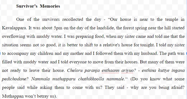
Since the past couple of years, landslides have been a common hazard in the geographical areas of the state of Kerala. August 8 2019; was a night in the lives of the people of Kavalappara. On that dreadful day, around 7.30 p.m. a large landslide brought on by torrential monsoon rain destroyed a small hamlet residing beneath Muthappan hill at Kavalappara, a section of the Western Ghats in the Nilambur assembly constituency in Malappuram, burying 59 persons alive.
This landslide affected 81 homes either completely or partially. Out of these, 46 settlements were just slightly impacted, while 35 settlements and their residents completely vanished. Additionally, the geological department stated that the area was unsafe for habitation. More than 100 families were forced to relocate as a result.
In 2019, compared to other districts, Malappuram got unprecedented rainfall. The average rainfall they experienced that year was 392.7mm. This excessive rainfall increased the pressure in the area through high infiltration, causing a sudden landslide. In 2019, landslides predominantly damaged the northern districts, whereas in 2018. (Rajesh, Kumar& etal,2021)
More than 100 households were affected by this disaster. In the case study titled; Post-landslide Investigation of a Shallow Landslide, they said 81 houses were partially and wholly affected due to this disaster. However many news reports are showing various data regarding housing losses. During primary data collection, researchers also inquire about the exact number of losses. However, due to some constraints, researchers cannot access the data. Now the victims of the Kavalappara Landslide are scattered in various places. This also creates a complication in obtaining the exact data regarding housing loss.
Most of them belong to the OBC category (74.14%). Only a few populations are included in the SC (6.90%) &ST (3.45%) category. The general category of this area is only 15.52%. They engage in agricultural-related works such as farming, tapping and coolie works.
Impacts of Housing and Livelihood – quantitative data

Figure 1: House Loss

Figure 2: Degree of Housing Loss
Among people who lost their houses due to landslides, 80% of houses were fully destroyed and 20% of houses were partially affected.

Figure 3: Livelihood Loss

Figure 4: Loss of Livelihood Asset
70.69% of the respondents lost their livelihood assets and 29.31% of the respondents did not lose their livelihood assets.
Housing Recovery and Livelihood Recovery

Figure 2: New House
96.55% of the people who lost their houses due to the landslide got a new house and 3.45% of people still did not get a new house.
Most of them received new homes. Due to some accountability and transparency problems in government, many still fight to get a house, even if only a small portion of the population still struggles to find a safe shelter and lives in rental housing and rehabilitation facilities. Additionally, it is simpler to get to the institutions, but they are still lacking resources like wood, water, and the abundance of nature.
Public-Private Partnership in Housing Recovery
In the housing recovery process, one can see the collaboration of the government and private funds. This kind of initiative is very good in the recovery process. However, the private funds should be allocated through the hands of the government. However, according to the information gathered from the respondents, the fund did not directly assist those affected by the disaster. Because of this activity, people do not have any idea about how much the real compensation is. This calls into question the transparency of the governance when dealing with the recovery process. Among the people who got new houses, 33 houses were built by the Lulu group, 2 houses were built by the Varun group, and some of the religious organisations also helped to construct the houses.

Figure 6: Compensation from the government
Gaps in Recovery
- Absence of an equitable distribution of livelihood compensation As a result of this, people are still struggling for their livelihood. The government gave 34.38% of the respondent’s compensation for livelihood asset loss and 65.63% of the respondents did not get any compensation for the livelihood asset from the government.
- The government did not take any action to restore the agricultural land. Due to this action, people lose the opportunity to do agriculture on their land. Due to this poor implementation, Kerala High Court expressed dissatisfaction towards the government. “It noted that the government has done nothing to restore land to its previous form and that it cannot continue as a mute spectator anymore” (July 17 2022, Times of India)
- In the housing recovery, every house is constructed alike. This is not adequate for every family.
- During the construction process, they excluded family members, especially women in decision-making. This suggests that male authority prevails inside the families. But women do the majority of our household duties. In this scenario, it is the responsibility of the planning team and other family members to involve women in the decision-making process for building a home.
- Authorities are responsible for getting the consent of the people before buying land for them.
From this data, it is evident government concentrates more on housing rather than livelihood recovery. In a recovery process, both are important for living. Otherwise, this livelihood vulnerability creates high risk among the people and they cannot cope with future disaster risk. So, the government should be responsible for avoiding additional vulnerabilities.
The Kattu Paniya community
Among the affected people by this disaster, was a major indigenous community, that suffered much because of the intersection of their pre-existing vulnerabilities with the vulnerability to this hazardous event; The Kattu Paniyas. Paniyas are one of the indigenous communities residing in the tribal belt of Kerala. Paniyans were bonded labourers. The welfare measures of the government have made the tribes dependent on others even for daily needs. In Malappuram, the Paniyan are known as Kattu Paniyans/Kurinhi Paniyan and they are different from the other Paniyan of the state (Rachel Santhosh, 2008). Kattu Paniya is a subgroup seen in the forest region of Nilambur (Malappuram District) leading a lifestyle of primitive tribes (Scheduled Tribes in Malappuram District, n.d.).
Tribals face intersectionality of vulnerability in the form of reduced access to health, education, housing vulnerability, land alienation and marginalisation. This intersectionality of vulnerabilities is also associated with the lesser participation of tribal communities in the decision-making process. Tribals are not homogenous. Some groups enjoy a high status, are more assertive and may have a larger share of development funds. PVTGs are more vulnerable among the tribal groups. The Kattu Paniya community of the Nilambur tribal belt belong to the PVTG category.
The Kattu Paniya of the Nilambur tribal belt is spread in different settlements including Kavalappara, Irulikunnu and Ambumala. In the landslides and floods of 2019, it was the Kattu Paniyas of Kavalappara settlement affected the most. The community has been living in a rehabilitation centre at Pothukal Panchayath for the past 3 years.
Life in rehabilitation centre
The auditorium opposite the Pothukal Panchayath Office, near the Pothukal private bus station is the rehabilitation centre. The researcher first visited the place in December 2021. The Kattupaniya families were rehabilitated to this shelter a couple of weeks after the landslide. Before shifting the families to this auditorium, they were sheltered at the Bhoodanam school. The researcher again visited the rehabilitation centre in August 2022. It was after the 3rd anniversary of the disaster event (August 8th 2019). The families have been living in the rehabilitation centre for the past 3 years.
The rehabilitation centre is almost 18 kilometres from the Nilambur main town and it takes almost one and a half hours of travel by bus/jeep from Nilambur to Pothukal. There is no public transport facility to Pothukal. The auditorium comprising a two-storeyed building houses the rehabilitation camp. The ground floor of the building was occupied by a grocery shop and a meat-selling shop. The entrance to the rehabilitation centre was through a congested path, between two shops.
The two-storeyed – auditorium has been the rehabilitation centre for 14 Kattu Paniya families for the past 3 years, affected by the Kavalappara landslide of 2019. Soon after the landslide, about 32 families (180 people) came to the rehabilitation centre. Many have left and now about 55 people live there consisting of 23 men, 20 women and 12 children. These people live in an area of about 2000 square feet. On one corner, outside the building, there is a small open space where families used to cook. They cook outside as there is not enough cooking space inside the hall. The hall, which is on the first floor, consisted of 2 toilets at one corner and the rest of the space was fully occupied by the families.
As the researcher entered the rehabilitation centre which is on the first floor of the building, a wash area could be observed on the right side and water was spread up all across the tiled floor. The air they breathed was full of odour from the toilet. Many people were sitting on the floor. Clothes were hung in the hall, by randomly tying ropes. There was a gas stove, which belonged to one of the families. This is the space where 14 families (about 43 people) have been cooking, eating and sleeping, for the past 3 years! This leaves a question mark to the right of a human being to live with dignity.
As with any other disaster which leaves a shadow on multiple aspects of human life, the Kavalappara landslide and the resulting life in the rehabilitation centre left vacant spaces in the lives of the indigenous community in terms of their livelihood, social connections, cultural practices etc. ― After the disaster, 32 families came into this rehabilitation centre…almost 180 people and they were accommodated in the two storeys of this building. Many families left this place and started living in rented houses. People with no other choices remained in the camp. “I couldn‘t afford one. I remained here with the rest of the 14 families. We received food items via ITDP and ration shops, but if somebody gets ill…. we are unable to take them to the hospital since we lack enough money for medicines” – said one of the survivors of the disaster who has lived in the rehabilitation centre for the past 3 years.
The reconstruction site – Anakkallu
Anakkallu is located between Nilambur main town and Pothukal town, almost 15 kilometres away from Nilambur. Anakkallu is almost 7-8 kilometres away from the actual Paniya settlement in Kavalappara. The researcher visited the reconstruction site in August 2022. The way to the new settlement area is almost one to two kilometres away from the main road. The path is not tarred. Both sides of the narrow path are surrounded by different kinds of vegetation including areca palm. Only private bus transportation is available at Anakkallu, which is also not frequent. To settle the Anakkallu bus stop people have to either walk or hire an auto rickshaw and pay 40 to 50 rupees. The resettlement area is located in a bit elevated area. The reddish soil in the area reminded the researcher of the disaster area, which was visited earlier in April 2021.
As the researcher reached the area where houses for almost 32 Kattu Paniya families are being constructed, it was clear that the majority of the houses remain incomplete. Despite incomplete construction, 5 families had shifted to the houses from the rehabilitation centre. Electricity connection is still not available in many houses. The houses are arranged in a top-to-bottom fashion on sloping terrain. House plots have been levelled off the sloping terrain. By standing at the entry point to the settlement, the researcher could see houses right at the bottom of the valley. All the houses are single-storeyed terrace buildings. Only limited space is available in between each house. Even though there were many houses remained incomplete in construction, a couple of Kattu Paniya families have already shifted to the Anakkallu and started living in even uncompleted houses, with no electricity supply. This is all because they had no choices and life in the rehabilitation centre was too tough.
There were no trees or greenery in this new area, while Kavalappara was a green place. Residents reported that it was much warmer here at the new site. Even during August, the researcher could find people sitting outside the house for a cool breeze. By standing at the top of the hill, the researcher could observe green hills on the four sides of the area. The researcher could realise the fact that this indigenous community which lived close to the outer edges of the forest is now supposed to live the rest of their life in a comparatively dry area.
The Drinking Water
Drinking water was another serious issue in the rehabilitation centre. ―The drinking water we get is of very poor quality. Many members of our family suffered from frequent stomach problems and vomiting. We were happy and healthy during the times we had drinking water from our chola” – says one among the Paniya community. Chola refers to a forest spring, where fresh water is available in plenty. This forest spring they used to depend on was situated near the Kattu Paniya settlement in the Kavalappara – Muthappan Kunnu region. In the rehabilitation camp, drinking water is provided from a bore well. Initially, the community faced health issues including stomach pain and vomiting after consuming this water at the camp. It took some time to get adjusted to this new ‗taste‘ of water‘ – he concluded.
The situation in Anakkallu is also not much better. Ever since the community left their original place – Kavalappara, the availability of good quality drinking water has become a major problem. Though they face issues related to drinking water at the rehabilitation centre at Pothukal, the real problems are yet to be faced at the Anakkallu where the resettlement is planned and carried out at a slow pace.
The drinking water availability at Anakkallu is a question mark in front of these indigenous people. At present, water is available from one bore well almost 200 metres away from the resettlement area. But for almost 32 families to live…this bore well is not an adequate source of drinking water. One of the rehabilitated family members in Anakkallu remarked about the ongoing case at the Manjeri court on the issue of drinking water availability at the resettlement area.
Cultural Alienation
The disaster-led displacement left this indigenous community alienated and losing their social connections left them in desolation and they remained in a situation in which they felt too embarrassed to seek help from others who lived in the Pothukal town. The cultural practices of this indigenous community are also affected by life in a rehabilitation centre. The temple where the community practises their rituals is situated at the Kavalappara, near the landslide area and is unaffected. Paniya still visits their old environment once in a while, which is slowly converting into a forest and is frequently visited by elephants. The shift to the rehabilitation centre affected their community practices since the distance to the temple increased.
Similar issues are prevailing in the resettlement area as well. The Anakkallu resettlement area lacks the space to perform the rituals of the community. “Still we go to Kavalappara to perform our rituals. It is very difficult to visit Kavalappara especially if it rains. We are afraid that another disaster may occur, if it rains heavily at Kavalappara. We need a place to worship our deity, close to our settlement. Here, there is no place for the same. Also it is our need to have our own space for cremating our people after death. Here very limited space is allocated for each family and no such facilities are available. This need was raised at the Ooru Koottam, last time”- said one of the women from the community.
The disaster recovery of the tribal community
The recovery phase of any disaster is one of the long-term and crucial phases in the post-disaster section of the overall disaster management cycle. Recovery is a broader term which includes the physical as well as the psychological aspects. It covers the broader aspects of socio-economic and cultural recovery. It is a clear-cut fact that disasters like landslides lead to the displacement of communities from a specific area since it is geographically highly vulnerable and the deformation of landform in the aftermath of the landslide makes it less eligible to inhabit. Hence unlike disasters like floods, landslides compel the communities to be displaced from their original surroundings. In the case of indigenous communities whose socio-cultural beliefs and practices are rooted within the area of living, it is a tough task to relocate as part of recovery. ‘When the Adivasis live in the forests, they have access to different kinds of vegetables, tubers, and fish and forest products. Once they are displaced from the forests, their food habits and diet change drastically. This is applicable even for the educated individuals. Also when they move out of their ‘Ooru’, they experience a language barrier. They have their dialect and language for communication in their Ooru for which they are ridiculed. When they live in towns, they get alienated from their language and their cultural values. The tribals consider the forest and their cultural values imbibed in it as sacred and when they move out of the forest they cannot preserve it’ (Chithra, 2019).
The Kavalappara landslide survivors who belong to the Kattu Paniya community face an incomplete housing recovery mainly because of the mismatches in the communication of information. Information communication is one of the major aspects in the post-disaster phase, especially during the recovery and rehabilitation process. The significance of providing accurate information regarding relief funds to the marginalised sections of society who lack access to information on their own is something that must be discussed. Here the Kattu Paniya community affected by the Kavalappara disaster is such a marginalised community who lack access to information unless the concerned authorities provide the same, that too in a language without jargon. Here what happened was the clear-cut illustration of a lack of access to information which led the families to incomplete housing. The families weren‘t informed about the fund for housing provided along with other monetary aids like the MP fund. Without knowing the fact, many families spent the money on other needs, which was provided for house construction.
The recovery from the Kavalappara disaster is still incomplete in the case of the Kattu Paniya tribal community. Recovery and rehabilitation without considering the peculiarities of an indigenous community like Kattu Paniyas who lived closer to the edges of forest land is more dangerous than the Kavalappara disaster which affected their lives.
Recommendations and Conclusion
Rehabilitation is the longest and most expensive phase of disaster management and should be accessible to all disaster survivors (Amatya et.al, 2020). Rehabilitation is defined as “a set of interventions designed to optimise functioning and reduce disability in individuals with health conditions in interaction with their environment (WHO, 2021). In the case of landslide-affected communities, the process of rehabilitation includes housing with proper sanitation and drinking water availability, access roads to the settlements and so on.
Authorities and decision-makers need to be aware of the problems that displaced families undergo when they reside in temporary shelters for long periods.
(a) Proper community – participation should be ensured in the rehabilitation and resettlement activities in a post-disaster scenario. It emerged that the tribal communities were not consulted while selecting the site for rehabilitation.
(b) District administration needs to take proactive measures to restore livelihoods. This is especially the case when the community displaced is indigenous and is considered particularly vulnerable. Their access to daily wage work depends on their social networks which get disrupted with displacement. Hence measures need to be taken to restore their livelihoods.
(c) The rehabilitation and resettlement activities should be carried out concerning the peculiarities of the affected community. Especially when it comes to the case of indigenous communities like Kattu Paniya, rehabilitation without giving priority to their community beliefs and way of life eventually affects their community life. This is clear from this study conducted among them.
(d) Information communication is one of the major aspects in the post-disaster phase, especially during the recovery and rehabilitation process. The significance of providing accurate information regarding relief funds to the marginalised sections of society who lack access to information on their own is something that must be discussed. Here in the case of Kattu Paniyas of Kavalappara, they weren’t informed about the fund for housing provided along with other monetary aids like the MP fund. Without knowing the fact, many families spent the money on other needs, which was provided for house construction. Therefore, proper information communication to marginalised sections like tribal communities is the need of the hour, so that post-disaster phases including resettlement can be completed.
Emerging frameworks on post-disaster vulnerability and post–disaster recovery reveal that post-disaster vulnerability is a major hindrance to successful post–disaster recovery.
- For housing rehabilitation, enough facilities and infrastructure must be offered. Authority must guarantee a clean, safe environment for everyone, especially for women.
- Equal distribution and recovery measures must be offered concurrently, particularly in the case of housing. Don’t discriminate solely based on a person’s class or caste.
- To guarantee that resources are given evenly to all of the individuals affected by a crisis, governance needs to be more transparent and accountable to the populace.
This study focuses purely on the post-disaster phase; especially the rehabilitation and recovery part of the Kavalappara landslide 2019. Post-disaster recovery is an important element in the disaster management cycle. When a disaster hits a community, response and recovery are the important parts, and people and authorities give attention to that area. But that attention slowly started to fade for some reason. Response is the immediate action taken within 2–3 days after a disaster. But in the case of recovery, it will take a long time. Because recovery is more than just rebuilding buildings, it must ensure that all aspects of physical, social, cultural, and environmental assets are restored and that their recovery can cope with future disaster risks. Examine how much loss occurs in housing and livelihood, how they recover in these two aspects, and what gaps occurred in the recovery process on the topic “post-disaster recovery: Kavalappara landslide.” From this study, the researcher understood, that they lost their houses, public infrastructure, livelihood opportunities and assets. In the case of housing and infrastructure, they partially recovered. However, in the cases of livelihood and assets, they are still struggling to recover. Hence, it is evident they are still vulnerable economically and physically. This vulnerability also affects other aspects of their lives, such as education, health, and social level. Even if a disaster hits the community, their situation is even worse than the previous one. A landslide occurred 3 years ago in Kavalappara, and the affected people are still in a haunting situation.
The findings of the study revealed that even after 3 years of the landslide event, the Kattu Paniya families remain in the rehabilitation centre, which is in the middle of a town. They are forced to live a life in an environment which is entirely different from their actual one. Also, the community face livelihood vulnerability mainly due to alienation from their social connections. They also face housing vulnerability due to a lack of proper information communication in the post-disaster phase regarding the relief fund allocations. The study also reveals that the rehabilitation process is conducted without properly understanding the cultural peculiarities of the community and without clearly understanding the actual needs of the community. In brief, there is a lack of proper community participation in the entire process of resettlement. The rehabilitation process can be successful if and only if it properly addresses the community’s needs. Otherwise, the post-disaster vulnerabilities will haunt the affected communities for a long period. Hence, disaster recovery should be more effective, which can ensure the coping capacity of the people to avoid future disaster risks.
- Ali, Fukkar (2006) Developmental Issues among the Paniyans of Nilambur: An Ethno HistoricalAnalysis. Indian History Congress Stable.
- Amatya, Bhasker; Lee, Su Yi; Galea, Mary; Khan, Fary (2020) Disaster Rehabilitation ResponsePlan Now or Never. American Journal of Physical Medicine and Rehabilitation.
- Andrew Simon, Arlikatti, Long Laurie and Kendra James, 2013, The effect of housing assistance arrangements on household recovery: an empirical test of donor-assisted and owner-driven approaches, Journal of Housing and the Built Environment, Vol. 28, No. 1.
- Anil Kumar, Raghunath Rajesh, Sarun S, Sheela A M and Vineetha P, 2021, Post Landslide Investigation On Shallow Landslide; A Case Study From Southern Western Ghats; India, Disaster Advances, Volume 14(7) July 2021
- Bhatt Mihir, 2012, Disaster Response Preparedness in India and China, Economic and Political Weekly, Vol. 47, No. 1
- Bhandari, 2013, Challenges of the Devastating Indian Landslides, Current Science Association, Vol. 105, No. 5
- Bryman Alan, 2012, Social Research Methods, Oxford University
- Busch Natan and Givens Austen, 2013, Achieving Resilience in Disaster Management: The Role of Public-Private Partnerships, Journal of Strategic Security, Vol. 6, No. 2
- Comerio Mary, 2014, Disaster Recovery and Community Renewal: Housing Approaches, Cityscape, Form Follows Families: Evolution of U.S. Affordable Housing Design and Construction, Vol. 16, No. 2
- Cook Nancy and Butz David, 2013, The Atta Abad Landslide and Everyday Mobility in Gojal, Northern Pakistan, Mountain Research and Development, Vol. 33, No. 4
- Crittenden Kathleen, Lamug Corazon and Nelson Gloria, 2003, Socioeconomic Influences on Livelihood Recovery of Filipino Families Experiencing Recurrent Lahars, Philippine Sociological Review, Vol. 51
- Food security cluster, 2013, livelihood recovery appraisal of households affected by flooding in 2010 and 2011 in Sindh and Balochistan, FAO
- Hsu Minna, Howitt Richard & Miller Fiona, 2015, Procedural Vulnerability and Institutional Capacity Deficits in Post-Disaster Recovery and Reconstruction, Human Organization, Vol. 74, No. 4
- Jauhola Marjeena and Mishra Niti, 2021, Disaster Recovery (After Catastrophes), Helsinki University Press.
- Joakim Erin and Wismer Susan, 2015, livelihood recovery after disaster, Taylor &Francis Group, Vol. 25, No. 3
- Khan Amir, 2001, IMPACT OF LANDSLIDE HAZARDS ON HOUSING AND RELATED SOCIO-ECONOMIC CHARACTERISTICS IN MURREE (PAKISTAN), Department of Economics, University of the Punjab, Vol. 39, No. 1 58
- Khattri Prashant, 2017, Rural Livelihoods and Natural Disasters: Observations from Flood Affected Bahraich District of Uttar Pradesh, Indian Anthropologist, Vol. 47, No. 2
- Khera, Reetika (2008) Starvation Deaths and ‘Primitive Tribal Groups’. Economic and Political Weekly.
- Nambudiri Sudha, 2021, Rare phenomena in Kerala caused 2019 floods, Times of India
- Neuman, Lawrence (2014) Basics of Social Research: Qualitative & Quantitative Approaches – 3rd edition. Pearson Education Limited.
- Nilambur, Chithra (2019) Dreaming of Forests of Freedom. The Research Collective
- Phelps Priscilla, Akbar Tahir and Mercadante Jared, 2006, Disaster recovery guidance series- Housing and settlements recovery, GFDRR
- Rovai Eugenie, 1994, The Social Geography of Disaster Recovery: Differential Community Response to the North Coast Earthquakes, Yearbook of the Association of Pacific Coast Geographers, Vol. 56
- Samir, 2013, Community Vulnerability to Floods and Landslides in Nepal, Resilience Alliance Inc., Vol. 18, No. 1
- Sara Garcia, 2017, The role of public-private partnerships in economic disaster recovery and economic resiliency, International Economic Development Council,
- Sliwinski Alicia, 2020, Post-disaster Recovery, Brill
- Tianchi Li, 1994, Landslide Disasters and Human Responses in China, International Mountain Society, Vol. 14, No. 4
- Tierney, Kathleen (2019) Disasters: A Sociological Approach. Polity Press
- Wilson Bruce and Wyn Johana, 1985, Livelihood and Social Division, Taylor & Francis, Ltd., Vol. 6, No.
Related Posts

The Return Diaspora: A Study on Gulf Returned Malayalees From Kerala
June 21, 2024
Post-Disaster Vulnerabilities And Disaster – Induced Changes In The Life And Livelihood Of Kattupaniya Tribal Community
December 15, 2023 December 19, 2023

Return Migration of Non-Resident Malayalees to Kerala: A Study During COVID-19 Period
July 17, 2023 July 17, 2023

About Akshara Sobhanan & Jilsha A B
Leave a reply cancel reply.
Your email address will not be published. Required fields are marked *
Save my name, email, and website in this browser for the next time I comment.
Advertisement
Case Studies and Numerical Investigation of Landslide Triggering Mechanisms in Western Ghats, Kerala, India
- OriginalPaper
- Published: 11 August 2023
- Volume 54 , pages 96–108, ( 2024 )
Cite this article

- Deepankar Choudhury ORCID: orcid.org/0000-0002-2331-7049 1 ,
- Tanmoy Das ORCID: orcid.org/0000-0002-6912-1105 1 &
- Vansittee Dilli Rao ORCID: orcid.org/0000-0003-1943-8910 2
668 Accesses
Explore all metrics
Due to significant rainfall during the monsoon, Kerala regularly sees landslides across the steep sloppy terrains of the Western Ghats. This causes significant harm to both man-made and natural ecosystems throughout several districts of the state. In order to find the root cause mechanisms of such failures, a finite-element-based stability analysis has been performed in this study. Additionally, fluctuations in several soil internal properties and deformation across time and space as a function of rainfall intensity have been discussed based on results of the recent literature. Further, Kerala is located inside a Stable Continental Region (SCR). Due to the presence of critically loaded faults dispersed across a wide region, the SCR seismicity includes destructive earthquakes and offers a significant overall danger. As many slopes in the area have already been undermined by prior landslides, even a small magnitude earthquake might cause slopes to fail or reactivate landslides. Therefore, in addition to static analysis, the performance of critically stable rainfall-affected slopes under earthquake conditions was described by explaining outcomes of the related literature. The methodology and results discussed in this article can be used to predict the performance of slopes situated in tropical regions under rainfall and earthquake conditions to prevent such calamities in the future.
This is a preview of subscription content, log in via an institution to check access.
Access this article
Subscribe and save.
- Get 10 units per month
- Download Article/Chapter or eBook
- 1 Unit = 1 Article or 1 Chapter
- Cancel anytime
Price includes VAT (Russian Federation)
Instant access to the full article PDF.
Rent this article via DeepDyve
Institutional subscriptions

Failure mechanism of a destructive landslide in Hosein Abad Kalpush Village, Semnan, Iran

Geotechnical Analysis of a Landslide in Nakorn Si Thammarat Province, Southern Thailand

Dynamic Stability and Landslide Simulations in Hilly Regions of Kerala
Explore related subjects.
- Geoengineering
IS 1893-Part 1 (2002) Criteria for earthquake resistant design of structures - Part 1: General provisions and buildings. Bureau of Indian Standards, New Delhi, India
Seeber L, Armbruster JG, Jacob KH (1999) Probabilistic assessment of earthquake hazard for the State of Maharashtra, India. The Government of Maharashtra Earthquake Rehabilitation Cell, Mumbai, pp 60
Dasgupta S, Pande P, Ganguly D, Iqbal Z, Sanyal K, Venkataraman NV, Gupta HK (2000) Seismotectonic Atlas of India and its environments. Special Publication Geological Survey of India 556, 86. Calcutta, India
Das T, Rao VD, Choudhury D (2022) Numerical investigation of the stability of landslide affected slopes in Kerala, India, under extreme rainfall event. Nat Hazards 114:751–785
Article Google Scholar
Technical Report by Kerala State Council for Science, Technology and Environment KSCSTE (2019) Committee to examine the causes of repeated extreme heavy rainfall events, subsequent foods, and landslides and to recommend appropriate policy responses, Government of Kerala. https://drive.google.com/open?id=1TmczTO2SbAssijbUeqQLXI3IZ_DUOk9s
Oh S, Lu N (2015) Slope stability analysis under unsaturated conditions: case studies of rainfall-induced failure of cut slopes. Eng Geol 184:96–103
Ering P, Babu GLS (2016) Probabilistic back analysis of rainfall induced landslide—a case study of Malin landslide, India. Eng Geol 208:154–164
Yang KH, Uzuoka R, Thuo JN, Lin GL, Nakai Y (2017) Coupled hydro-mechanical analysis of two unstable unsaturated slopes subject to rainfall infiltration. Eng Geol 216:13–23
Vadivel S, Sennimalai CS (2019) Failure mechanism of long-runout landslide triggered by heavy rainfall in Achanakkal, Nilgiris. India J Geotech Geoenviron Eng 145(9):04019047
Rajendran CP, John B, Sreekumari K, Rajendran K (2009) Reassessing the earthquake hazard in Kerala based on the historical and current seismicity. J Geol Soc India 73(6):785–802
Das T, Rao VD, Choudhury D (2023) Seismic stability and deformation analysis of a southern Indian hill slope by finite elements. Nat Hazards Rev 24(2):04022050
Sarma SK (1979) Stability analysis of embankments and slopes. J Geotech Eng Div 105(12):1511–1524
Koppula SD (1984) Pseudo-static analysis of clay slopes subjected to earthquakes. Géotechnique 34(1):71–79
Leshchinsky D, San KC (1994) Pseudostatic seismic stability of slopes: design charts. J Geotech Eng 120(9):1514–1532
Choudhury D, Basu S, Bray JD (2007) Behaviour of slopes under static and seismic conditions by limit equilibrium method. In: Tulla FS, Nicholson PG (eds) GEO-DENVER 2007, Geotechnical Special Publication No. 161, ASCE, pp 1–10. USA
Chatterjee K, Choudhury D (2014) Seismic analysis of soil slopes using FLAC2D and modified Newmark approach. In: Abu-Farsakh M, Yu X, Hoyos LR (eds) Geo-Congress 2014: geo-characterization and modeling for sustainability, geotechnical special publication 234. ASCE, Reston, VA, pp 1196–1205
Chapter Google Scholar
Hazari S, Ghosh S, Sharma RP (2017) Pseudo-static analysis of slope considering log spiral failure mechanism. In Proc., Indian Geotechnical Conf. 2017 (IGC-2017). New Delhi, India: Indian Geotechnical Society
Das T, Choudhury D (2023) Finite element based pseudo-static stability analysis of soil slope under combined effects of horizontal and vertical seismic accelerations. In: Karkush M, Choudhury D, Han J (eds) book entitled ‘Current Trends in Geotechnical Engineering and Construction’ 3ICGE-Iraq 2022. Springer, Singapore, pp 365–376
PLAXIS 2D: [Computer software] (2019) Bentley Systems International Limited. Netherlands
Shreyasvi C, Venkataramana K, Chopra S (2019) Local site effect incorporation in probabilistic seismic hazard analysis–A case study from southern peninsular India, an intraplate region. Soil Dyn Earthquake Eng 123:381–398
Kolathayar S, Sitharam TG, Vipin KS (2012) Deterministic seismic hazard macrozonation of India. J Earth Syst Sci 121(5):1351–1364
Article ADS Google Scholar
Parvez IA, Magrin A, Vaccari F, Mir RR, Peresan A, Panza GF (2017) Neo-deterministic seismic hazard scenarios for India—a preventive tool for disaster mitigation. J Seismol 21(6):1559–1575
Psarropoulos PN, Tsompanakis Y (2008) Stability of tailings dams under static and seismic loading. Can Geotech J 45(5):663–675
Hung C, Lin GW, Syu HS, Chen CW, Yen HY (2018) Analysis of the Aso-bridge landslide during the 2016 Kumamoto earthquakes in Japan. Bull Eng Geol Environ 77:1439–1449
Oberhollenzer S, Tschuchnigg F, Schweiger HF (2018) Finite element analyses of slope stability problems using non-associated plasticity. J Rock Mech Geotech Eng 10(6):1091–1101
Çadır CC, Vekli M, Şahinkaya F (2021) Numerical analysis of a finite slope improved with stone columns under the effect of earthquake force. Nat Hazards 106:173–211
Ma Z, Liao H, Dang F, Cheng Y (2021) Seismic slope stability and failure process analysis using explicit finite element method. Bull Eng Geol Environ 80(2):1287–1301
Sahoo PP, Shukla SK (2021) Time-history analysis of soil slope subjected to seismic loadings. Soil Mech Found Eng 58(2):130–137
Morales-Esteban A, de Justo JL, Reyes J, Azañón JM, Durand P, Martínez-Álvarez F (2015) Stability analysis of a slope subject to real accelerograms by finite elements. Application to San Pedro cliff at the Alhambra in Granada. Soil Dyn Earthq Eng 69:28–45
Download references
Acknowledgements
The authors would like to express gratitude to Dr. K. P. Sudheer, Executive Vice President of the Kerala State Council for Science, Technology, and the Environment, Kerala, India, for inviting the first author and allowing team to conduct site visits for a thorough investigation of the landslide-affected areas in Kerala. Also, some of the soil data provided by Prof. S. Chandrakaran of NIT Calicut is deeply acknowledged. In addition, Dr. Anindya Pain's (Scientist, CSIR-CBRI Roorkee) assistance in gathering several site data is highly acknowledged.
For this work, no external funding was provided.
Author information
Authors and affiliations.
Department of Civil Engineering, Indian Institute of Technology Bombay, Powai, Mumbai, 400076, India
Deepankar Choudhury & Tanmoy Das
Atkins Ltd., Epsom, KT18 5BW, UK
Vansittee Dilli Rao
You can also search for this author in PubMed Google Scholar
Corresponding author
Correspondence to Deepankar Choudhury .
Ethics declarations
Conflict of interest.
The authors disclose that they have no conflicting interests.
Additional information
Publisher's note.
Springer Nature remains neutral with regard to jurisdictional claims in published maps and institutional affiliations.
Rights and permissions
Springer Nature or its licensor (e.g. a society or other partner) holds exclusive rights to this article under a publishing agreement with the author(s) or other rightsholder(s); author self-archiving of the accepted manuscript version of this article is solely governed by the terms of such publishing agreement and applicable law.
Reprints and permissions
About this article
Choudhury, D., Das, T. & Rao, V.D. Case Studies and Numerical Investigation of Landslide Triggering Mechanisms in Western Ghats, Kerala, India. Indian Geotech J 54 , 96–108 (2024). https://doi.org/10.1007/s40098-023-00763-y
Download citation
Received : 03 December 2022
Accepted : 25 July 2023
Published : 11 August 2023
Issue Date : February 2024
DOI : https://doi.org/10.1007/s40098-023-00763-y
Share this article
Anyone you share the following link with will be able to read this content:
Sorry, a shareable link is not currently available for this article.
Provided by the Springer Nature SharedIt content-sharing initiative
- Rainfall intensity
- Pore water pressure
- Finite element Analysis
- Time response analysis
- Find a journal
- Publish with us
- Track your research
- Let me explain
- Yen Endra Kelvi
- SUBSCRIBER ONLY
- Whats Your Ism?
- Pakka Politics
- NEWSLETTERS
'Been 4 months, where are our houses?’ Kavalappara landslide survivors ask Kerala govt

It was on a rainy afternoon of August 8 when 19-year old Harish and his brother, Jishnu, left their uncle’s house on Muthappankunnu hill in Kavalappara, Malappuram. The brothers crossed a bridge over a stream next to their house in Nilambur, to rescue a family of 8 who had been trapped beneath a landslide on the other side of the hill.
As they reached the spot of the landslide, the brothers saw neighbours frantically search through the pile of rubble where their house once stood. The house belonged to Mahmood and his family of 7, which was the first to crumble under the landslide in the region.
Mahmood's daughter - 17 year old Fahmida - had managed to climb a coconut tree and from atop she watched her family being wiped away by the waves of mud and rock. Fahmida is the sole survivor of the landslide from her family.
As for Harish and Jishnu, that was the last time the brothers saw their uncle - Vijayan. The deadly landslide which wiped out the entire hill on August 8 claimed the lives of 59 residents including Vijayan and his family.
However, this is a 4-month old story and for the families that are still recovering, the absence of help from the government has upset their lives further. "We lost our loved ones, our land and our house. But we still haven’t received any help from the government,” Harish says.
Over 72 families in the landslide affected region of Kavalappara in Nilambur have been waiting for the state to release funds it had promised to resettle the survivors.
Within days of the calamity, the government had announced a sum of Rs 10 lakh to resettle each family whose land and residence was destroyed by the landslide. However, none of the affected families have been rehabilitated to date, Harish says.
“They has said that they would allot a few acres of land for us near Kavalappara to build houses. So far, the state has only released ex gratia to families of the landslide victims. But what about those who have lost everything and are still living. Why is the government not thinking about us?,” asks Anilkumar, another resident who was forced to vacate his house in the area after August 8.
Other than the 72 families that lost their houses, another 100 families living in a 200 metre radius of the site of the landslide were asked to move away as the region was declared geographically uninhabitable.
During this arduous wait, Anilkumar and his family have lived with their kin, shared single room residences with two or more families and even moved back to their old house as they could not afford to pay rent.
“One month ago we moved back to the old house in Kavalappara. But even if it drizzles, we rush out of the house. We are scared to live here but have no choice,” Anil says.
Harish and Jishnu too echo similar sentiments as they struggle to find a roof over their heads post the landslide.
“We spend Rs 3000 on rent every month. For the first 3 months, the state government supported us but now we have to pay from our pockets,” Harish adds.
On Sunday, the 172 families in the region observed a token protest against the state government.
Where did the funds ago?
According to Rajesh, a native of Kavalappara who led the protests on Sunday, no local body committee has been constituted by the state government to manage the allocation of funds to be distributed to affected families
“Each family has been promised Rs 4 lakh to build a new house and Rs 6 lakh for new land. The government said it will identify the land and build a house for the families. Over the last few months, we have approached the Tahsildar, Village Officer, Land Revenue Commissioner and others regarding the status of rehabilitation. Nobody has any answers for us,” Rajesh alleges.
While there is reportedly no government appointed committee to oversee the rehabilitation process in Kavalappara, Save Nilambur, a campaign headed by MLA PV Anwar and MP PV Abdul Wahab had organised fund collection drives for rehabilitation of the landslide survivors. However Rajesh alleges that the 172 families awaiting rehabilitation have been kept in the dark about this campaign and the fund collected by the leaders.
“We asked the district Collector regarding Save Nilambur and the fund collected for rehabilitation. He told us that the campaign had nothing to do with the state government and was independently run by the MLA and others,” Rajesh tells TNM.
According to Anilkumar, members of the Nilambur block panchayat, including President PP Sugathan, promised that the first list of beneficiaries would be published by January. “But they have been giving us the same excuse for the past 4 months,” he added.
Speaking to TNM, Malappuram District Collector Jafar Malik said that the district administration had completed the survey of families who’ve lost both land and house, among other categories. In Nilambur, a total of 230 families living in and around the landslide hit area have been instructed to shift from the location, which is found to be unsafe for inhabitation post the calamity. These families, who have lost both their land and house, are eligible to receive Rs 10 lakh (Rs 6 lakh for land and Rs 4 lakh for house) as relief from the state. However, the families have to identify the land they want to purchase and apply for the fund, the Collector added.
“We will only provide land for the 27 tribal families residing in the relief camp in Nilambur currently. The other families have to identify the land they want to purchase. On verification of this land as well as the beneficiary’s eligibility, an advance of Rs 50,000 will go to their account from the state. Following registration of the land, Rs 5.5 lakhs will be directly transferred to the seller’s account. This is to ensure that beneficiaries use the amount to buy land. After purchase of land, the first instalment of Rs 95,100 will be transferred to them to start building a house,” he added.
The Collector confirmed that post survey, a list of eligible families eligible has been sent to the Land Revenue Commission office and they will verify the list before the finance department releases the funds.
Regarding the delay in disbursement of funds, the Collector said, “The relief amount comes from the Chief Minister's Distress Relief Fund (CMDRF) - and the State Disaster Response Force (SDRF) - from the centre. Some amount of delay occurs while getting fund amounts cleared from SDRF.”
A different story in Puthumala
While Kavalappara’s residents suffer from the collective apathy of the block panchayat and the state government, in the neighbouring district of Wayanad, survivors of another landslide which struck the Puthumala village in Meppadi on August 8, will soon be relocated to an eco-friendly township located 2 kms from the site of the landslide.
The township has been designed to accommodate 64 families who lost their houses to the landslide which wiped out Puthumala. While these 64 families lost their houses in Puthumala and 30 other houses had been partially damaged, the landscape of the region had completely changed following the calamity. Where the village of Puthumala once stood, a river which has changed its course now flows, making it impossible for residents to go back to the village.
In order to plan the project, a People’s Committee has been convened, consisting of panchayat members including the president and the secretary as well as the MP, MLA, District Collector, District Block President, and other political party representatives. Apart from the 64 families, the new township will also accommodate 30 other families whose houses on Puthumala have been partially damaged and have been forced to move out. Additionally, the township will also be built in to house flood victims from other parts of Kerala who wish to live there, taking the total count of houses to 144.
Built on 11.75 acres of land, the township is the collective effort of panchayat members and survivor families, and will house a play group, a school, an anganwadi, a local health centre, a women’s self help group centre and a hall which will operate as a shelter home/relief centre with the capacity to accommodate 5000 people inside, Sahad KK, Panchayat President of Meppadi told TNM. It is situated about 2 kilometres from the site of the landslide in Puthumala, in the Vazhakkala estate – a 28-acre private property.
“With the self-help group centre, we aim to provide a space for women to practice their skills and earn a living. It can be anything from pickle making to cloth bag manufacturing. The relief centre hall was envisioned keeping in mind possibility of future calamities,”Sahad added.
The township will also run on solar power and have rainwater harvesting equipment. G Shankar, the Padma Shri award winning architect, famous for using sustainable material and locally available products in his construction to promote eco-friendliness also inspected the site of the new township and will help in its execution.
Meanwhile, the old site of the Puthumala village which had been wiped away by the landslide will be turned into a memorial garden by the Panchayat. According to panchayat members, the land and damaged houses will be retained as such and photographs and newspaper clipping will be placed in memory of the calamity that took place on August 8, 2019. The place will also remain open to tourists which will house a memorial garden.
Related Stories

- Entertainment
- Life & Style
To enjoy additional benefits
CONNECT WITH US
Kavalappara landslide: Malappuram needs to learn from the disaster
The loss of property and damage to sources of livelihood remain incalculable as the destruction has been widespread.
Updated - August 20, 2019 10:42 am IST
The eco-rich Malappuram district, its proud residents believe, is rich with geographical diversities — except for deserts.
But monsoon after monsoon, the densely populated district has been proving that it is ‘rich’ in natural disasters too. In recent times, there has not been a monsoon without a landslip. The casualty count tends to rise by the year. In last year’s floods 46 lives perished, though Malappuram was considered less affected than other districts.
Rising disaster toll
And the result: this land of exceptional camaraderie and humanism continues to contribute generously to the State’s disaster toll.
Take this month’s rain devastation, for instance. The Western Ghats grama panchayat of Pothukallu near Nilambur was the tragic centre of landslips, destruction and loss of human lives in the State. More than a week after a landslip struck Kavalappara in the panchayat, over 50 members of 18 households were buried alive when a large portion of a hillock slid down levelling off dozens of hectares of rich farmland and knocking down homes and public utilities.
The total number of human lives lost in this year’s monsoon fury in the district is nearly 70 and counting. Most victims of landslips and mudslides in the district were socio-economically backward. They lived in the vulnerable fringe areas as they had few alternatives.
The loss of property and damage to sources of livelihood remain incalculable as the destruction has been widespread. Paathar, a lively bazaar in Pothukallu, was wiped out leaving a gigantic scar in its stead. Across the district, hundreds of houses got mauled. Business was hit like never before as unexpected inundation destroyed merchandise worth crores of rupees in towns like Nilambur, Kondotty, and Malappuram. Besides the district’s fragile rural economy, already deeply hurt by demonetisation and reverse migration from the Gulf, is in ruins.
Vandalising the hills
Apparently, nature has responded furiously to human vandalism. The district is now paying the price for mindless development carried out in recent decades by destroying hills, forests, waterbodies, and wetlands. For instance, large portions of Oorakamala and Cheruppadimala, two of the highest hills in the district, were ruthlessly carved up for granite and laterite. Hills have been grotesquely wounded by quarrying; forests have been shaved off by commercial agriculture; paddy fields and ponds which in the past served as buffer for floodwaters have turned into modern mansions; rivers have shrunken and streams vanished.
The number of deaths by drowning in floodwaters was, however, few. Mudslides turned out to be the real villain. And, it was not rain alone that triggered such
a mammoth mudslide as the one that took away 18 families of Kavalappara.
Not a stand-alone
Experts say deforestation and reckless commercial interventions on land have destabilised the environment. When rain of extreme intensity pours own, the precarious hills inevitably succumb, causing casualties and destruction. The impact of large-scale rubber plantations on the sloping Kavalappara hills apparently colluded with the extraordinary rain in taking so many human lives. Elsewhere in the district too, the situation was no different.
Kavalappara, experts suggest, is not a standalone disaster. Nor a once-in-a-lifetime event. Going by the past natural disasters, especially the regular annual landslips, coupled with the outrageous speed of environmental destruction, it is a road-sign to the future. Be prepared for more Kavalapparas.
(MALABAR MAIL is a weekly column by The Hindu’s correspondents that will reflect Malabar’s life and lifestyle)
Published - August 19, 2019 11:22 pm IST
Related Topics
Series - 23 stories.
Top News Today
- Access 10 free stories every month
- Save stories to read later
- Access to comment on every story
- Sign-up/manage your newsletter subscriptions with a single click
- Get notified by email for early access to discounts & offers on our products
Terms & conditions | Institutional Subscriber
Comments have to be in English, and in full sentences. They cannot be abusive or personal. Please abide by our community guidelines for posting your comments.
We have migrated to a new commenting platform. If you are already a registered user of The Hindu and logged in, you may continue to engage with our articles. If you do not have an account please register and login to post comments. Users can access their older comments by logging into their accounts on Vuukle.
Kavalappara Landslide
You don't have enough point to see this page.

| Main Information | |
| : Kavalappara Landslide | |
| : 11:24:37.29 N | |
| : 76:14:10.25 E | |
| Location | |
| : Malappuram | |
| : Kerala | |
| : India | |
| Reporter | |
| : Maneesha Vinodini Ramesh | |
| : Maneesha Vinodini Ramesh | |
| Landslide Type | |
| : Debris, Earth | |
| : Flow | |
| : Very Rapid | |
| : Deep-Moderate | |
| : Steep | |
| : Large | |
| Date of Occurence | |
| : Aug 08, 2019 | |
| Other Information | |
| : Farming, River : Human settlement, Road, River | |
| : Currently active | |
| : Human activity and rainfall | |
| : 69 | |
| : over 39 houses and a walkover bridge were completely washed away | |
| : | |
| : | |
| : | |
| : - | |
| : | |
| : - | |
| : - | |
| : - | |
| : | |
Month of August experienced heavy rainfall on the Western Ghat mountain ranges of southern India in 2019 with exceptionally heavy rainfall i.e. 400% over the normal average during 5 cumulative days resulting in the devastating landslide on 8th August 2019. It was difficult to estimate the actual loss however 69 casualties, 39 completely damaged houses along with roads, utilities and other infrastructure damages were recorded during our survey. The children and adults who managed to escape their death were completely traumatised and were unable to talk. Through field and desk geoscientific investigation it was found that the mismanagement of land use, unscientific slope modification, disruption of free flow of drainage, added with huge amounts of water due to heavy rainfall leading to supersaturation of highly weathered and structurally disposed debris material overlying Archaean bedrock and toe erosion due to flooded river resulted in this landslide. Although the slide happened in a rapid way but precursory signature as cracking and rumbling sound was heard before the actual event. However people were trapped and could not go away as their escape root was flooded. The landslide happened in the northern trifurcated downslope segments as the three 1st order drainage courses carried the discharge of debris and water. The communities living in high hazard prone areas need to be prepared as a resilient community by empowering them with deployment of multi-scale early warning and risk management systems. | |
ICL HEADQUARTERS
Administration office 138-1 Tanaka-Asukai cho Sakyo-ku Kyoto 606-8226, Japan
- +81 (75) 723 0640
- +81(75) 950 0910
OPEN ACCESS BOOK SERIES
The Kyoto Landslide Commitment 2020 secretariat examined potential new mechanisms/infrastructures to develop the KLC2020. As a result, a new open access, free-of-charge publication focusing on practical applications of landslide research and technology for the benefit of society was planned.

KYOTO LANDSLIDE COMMITMENT 2020

The Sendai Landslide Partnerships 2015-2025 was established in 2015. Read More
This partnerships has to be completed in 2025. The partners pursued to establish a stable and longer partnerships. As a result, the Kyoto 2020 Commitment for Global Promtion of Understanding and Reducing Landslide Disaster Risk (Kyoto Landslide Commitment) was launched in 2020. Read More

‘The Buckingham Murders’ review: An unfussy police procedural with a dodgy heroine

Adding more good-quality protein to the diets of older adults can combat muscle loss

What Don Bradman thought of the first Indian team that toured Australia

Himachal Pradesh: With Sanjauli mosque, BJP once again uses urban planning as a Hindutva weapon

Visa-free destinations, Bollywood inspiration: Indians are travelling abroad in record numbers

Sitaram Yechury (1952-2024): Communist leader who dreamed of a better India and a better world

In Nepal, high demand for a fern found deep in the jungles is driving human-tiger conflict

How 19th-century fiction writers popularised tourism, and also poked fun at rich European tourists

Can the return of Engineer Rashid disrupt Kashmir’s politics?

‘Tanaav 2’ review: Truncated season leaves us hanging
Could the deaths caused by the Wayanad landslide been avoided?
Kerala needs a disaster mitigation strategy rather than a disaster management plan, experts say..

Areas previously with human habitation, turning into bare, flattened mud grounds, scattered with rock boulders, are now a familiar sight for the people of Kerala. The 2018 deluge that killed over 450 people shifted the state to a disaster-vulnerable state, with a consecutive flood in 2019 and devastating landslides in the years following.
The state woke up to similar sights on July 30 when a catastrophic landslide occurred in the serene, northern district of Wayanad. According to the press statement early on August 2,from the Chief Minister’s Office,199 people have been reported as dead so far. Another 86 people are undergoing treatment.
The state quickly resorted to rescue operations and risk management, even as experts and environmentalists criticised the government for not developing a strategy for risk mitigation.
The origin of the calamity is reported to be the Iruvazhinjhi river which flows down to three villages named Mundakkai, Chooralmala, and Attamala in Vythiri taluk and merges with the Chaliyar river. Twenty-six dead bodies, along with several unidentified body parts, were found in the Chaliyar river at Pothukallu in Malappuram, a nearby district. The landslide also completely buried a government vocational higher secondary school.
Kerala Chief Minister Pinarayi Vijayan called it one of the worst disasters the state ever witnessed. The state has previously witnessed devastating landslides in Pettimudi in the Idukki district in 2020, which killed 66 people, in Kavalappara in Malappuram in 2019, which killed 46 people, and Puthumala in Wayanad, in which 11 people lost their lives. Relentless, heavy monsoon triggered these landslides.
Sridhar Radhakrishnan, an environmentalist, considers the landslide as the outcome of the state overlooking risk mitigation. “The approach should be about setting up risk assessments and mitigative measures, creating a resilient strategy, but instead, it is about disaster management, and the state has mastered it,” he told Mongabay India.
Sridhar pointed out that a landslide happened in the same region in 1984, and because of the landslide in Puthumala in 2019, the region has been identified as a landslide-prone area, which means that the authorities have to be more vigilant about these regions when there are incessant heavy rains. He suggested shifting people from these regions to safer areas gradually but permanently.
“The rehabilitation didn’t happen even in the high-priority areas. When something like this happens, you should have an early warning system,” Sridhar said. “There should be a warning system for landslides which is same as in the case of heavy rains. It happened not because of a human error but because of human negligence. If warnings had been taken seriously, there would have been enough time to move people out. Landslides can’t be avoided, but causalities can.”
Mass graves being dug on a war-time basis in a public graveyard in #Wayanad to bury unidentified body parts of landslide victims' fished out from the Chaliyar river and adjoining sites. The remains are in extremely bad condition, said officials. pic.twitter.com/0lnv7XmpQH — Vishnu Varma (@VishKVarma) August 2, 2024
Importance of alerts
The Hume Centre for Ecology and Wildlife Biology has been collecting, analysing, and sharing data on rainfall in Wayanad district , since 2018. “We have a daily updating system,” CK Vishnudas, Director of Hume, told Mongabay India . “The updates are put on a group in which all the stakeholders, like the District Collector and Disaster Management Authority people, are there. We have a clear daily analysis, providing separate data on highly saturated regions, averages about panchayat, and district-wise details. Also, we have a grid that analyses the rainfall every 25 kilometres. Even on July 31, two regions crossed 4000 millimetres of rainfall; in two other places the rainfall was 3600 mm; this is heavy. Normally, rainfall would come to 3000 mm in the monsoon. But this year, it has been consistently heavy rains, and by July 20, soil became saturated in all regions. Soil saturation water-bearing capacity means streams would originate, water flows out of them, and heavy water inflow in all rivers.”
The district had witnessed landslides in the same region in 2020, and the authorities shifted people because of the alerts provided by Hume, he claimed. “This year, our warning has specific details about soil saturation and the vulnerable regions, naming the villages that have been cut off. We had given an update about the intensive rainfall and a warning that this could be the expected rainfall in the region overnight, which could trigger a landslide,” he added. But there has yet to be a proactive step from the authorities. “This is something we could have avoided, I stand by that,” he asserted.
Experts say that there should be a focus on mitigating risks and action based on precise warnings on soil saturation and vulnerable areas, that are available, could help mitigating the impact of landslides in the district. Image by special arrangement.
“Water has memory, it remembers its course, even centuries after it was diverted. It’s dangerous to attempt to trick nature by occupying the path of a river.” ‘The river reclaimed its course’: Geologist explains Wayanad landslide https://t.co/v7DJg7MLtv # — Dolly Kikon (@DollyKikon) August 2, 2024
Meanwhile, in a Rajya Sabha speech on July 31, Union Home Minister Amit Shah said that the Centre gave early warnings to the Kerala government on July 23, seven days before the incident. On July 26, he said, a warning was given there was a chance of heavy rainfall of more than 20 centimetres and there were chances of landslides. He questioned why there was inaction by the state government despite the warnings.
However, Kerala Chief Minister Pinarayi Vijayan, refuted the claim, saying that the Union Home Minister has presented information in the Parliament that is inconsistent with the facts. The chief minister added that the India Meteorological Department’s warning was that rainfall would be between 115 and 204 mm. However, the actual rainfall – 572 mm in 48 hours – was much higher. The area received 200 mm of rain in the first 24 hours and 372 mm in the next 24 hours.
“The area had never been on red alert before the disaster,” the chief minsiter said at a press conference. “However, after the incident, a red alert was issued at six o’clock in the morning [of July 30] after the landslides occurred. On July 29 at 2 pm, the Geological Survey of India issued a green alert for July 30 and 31, indicating a possibility of minor landslides or rock bursts. However, by that time, heavy rain had already occurred, and the landslide had taken place.”
From July 23 to 29, the Central Water Commission, responsible for issuing flood warnings, did not issue any warnings for either Iruvazhinji Puzha or Chaliyar, he added.
Warming Arabian sea
S Abhilash, Director of the Advanced Centre for Atmospheric Radar Research at the Cochin University of Science and Technology attributed the excessive rainfall to the cloudbursts from high water accumulation over the southeastern part of the Arabian Sea. The Arabian sea lies to the west of Kerala. Earlier research by Abhilash and others found that rainfall over the west coast of India is becoming more convective.
“Cloudbursts occurring under favourable ocean-atmospheric conditions may leave a vast area of the state vulnerable to flash floods and landslides anytime during the monsoon season,” he said. “The paper [published in 2022] was based on the Kavalappara and Puthumala landslide. Post that, such disasters kept occurring, landslides happened in Pettimudi [Idukki district] in 2020, in Koottickal [Kottayam district] in 2021, and a major cloudburst in Kalamassery in Kochi [the first-ever cloudburst in the state in May 2024]. As an indication of cloudburst, we cited the increasing depth of clouds forming in the southeastern Arabian Sea, causing increasing rainfall.”
According to him, the warming of the Arabian Sea and the increasing depth of cloud is a clear signal of climate change. “Earlier, the clouds in the southeastern part of the Arabian Sea were mostly formed in the northern region, which caused frequent landslides in the Konkan region,” said Abhilash. “A mesoscale mini cloudburst has the potential to trigger a landslide or cause a flood if the rainfall is ten centimetres to 15 centimetres in one hour, considering the vulnerability of the Western Ghats. Mini cloudbursts in this region will have the same impact that the major cloudbursts have in the Himalayan region.”
He also blamed the authorities for not issuing a warning, sensing the pattern of the rains. “This is not because of the lack of data; we should be able to sense from the rain pattern,” he said. “The alert system is not reaching the last mile people.”
A source in the government, who asked for anonymity, rejected this claim, saying that appropriate action was taken and the deaths occurred six kilometres away from the area where the landslide originated.
Landslide impacts
Sajin Kumar KS, a geologist and Assistant Professor at the University of Kerala, also said that the recent landslide occurred six kilometres inside a dense forest. “Factors ignored were those that could be ignored,” he said. “There was no anthropogenic influence. There are many landslide susceptibility maps prepared by different methods, and if you place the latitude and longitude of the [recent] landslide, it falls exactly under the high landslide zone of that area.”
He noted that while the landslide prediction was accurate, the impact of the landslide that flowed beyond the point of origin, was in regions, which are not usually landslide prone, such as Chooralmala, because of the way it flowed.
In 2018, Sajin Kumar coordinated a five-day study about landslides in Idukki during the floods that year and concluded that human activity and presence was the reason for the landslides in Idukki.
Talking about the recent disaster, Sajin Kumar said, “Two things went wrong. One is people living on the banks of rivers on the plains where water can flow during the heavy monsoon seasons. Two, we don’t have a map predicting the flow path of the landslide, the direction it flows, we lack that modeling. This is an area of active interest worldwide. Almost all developing countries are about to develop such a map, but we are in the infant stage. All the devastating landslides occurred in the non-susceptible areas, especially Pettimudi, Puthumala, and the latest one – the origin of the landslide was in a susceptible area, the casualty occurred in a landslide-free zone.”
The non-implementation of the Western Ghats Ecology Expert Panel report, led by prominent ecologist Madhav Gadgil, which warned against anti-environmental activities in eco-sensitive areas in Wayanad, has also been brought up by experts, after the recent landslide. Environmentalist Sridhar Radhakrishnan blamed this non-implementation on successive state governments.
Sajin Kumar, however, has a different view. “…The [recent] landslide occurred in deep forests where human beings didn’t even enter. Not only Gadgil’s report but any Geological Survey of India map shows it as a landslide-prone area. Any map will say that. But that is not the point. We failed to identify the areas that the landslide will flow down to. The government should shift people and take precautionary measures based on quantifying the rainfall threshold, and how much is required to trigger a landslide. The government authorities acted based on this rainfall prediction, on July 30, rehabilitating people from six residential areas. The government issued an orange alert for the region though it later turned into a red alert,.”
Technically the government does not have the authority to move people living in the safer zones, he added, referring to the non-landslide prone zones, where, in fact, the impact of the recent landslide was seen as the landslide flowed. The origin of the landslide is predictable but its pathway, which are the areas through which it will move, is not predictable and hence it is not always possible to send alerts for those areas, he explained.
“An insert soil moisture testing instrument can be used to check soil water content and threshold. But the most important is landslide runout zone mapping,” he suggested. Landslide runout analysis is used to simulate the motion of past landslides to predict the motion of potential future landslides. This is often required in the context of a landslide hazard or risk assessment.
Abhilash said that the authorities failed in risk mitigation which experts have been advocating for since the Cyclone Ockhi in 2017. He hoped calamities of lesser magnitude in the future will not be trivialised solely because the state witnessed something of this magnitude.
This article first appeared on Mongabay India.
- Wayanad landslide
- Disaster management

Memories of landslide still haunt Kavalappara

Kavalappara will never forget August 8, 2019. At 7.30pm on the fateful day, a massive landslide triggered by intense monsoon rain buried 59 residents alive, wiping out a small community living beneath Muthappan hill at Kavalappara, a part of Western Ghats in the Nilambur assembly constituency in Malappuram.It was raining when Express team reached Kavalappara then. The entire area had a muddy red hue as the deep-red laterite soils that had caved in mixed with the rain water and flooded every nook and corner of the valley including the Chaliyaar river.
Now, almost one-and-a-half years later, the desolate patch of land is covered in plants. After the landslide, the government, aided by socio-religious outfits, rehabilitated 148 families from the deadly valley and provided all basic infrastructure. The authorities set up colonies dotted with 600-sqft houses, twin road connectivity, power and water connections. However, those who survived have yet to move on, emotionally.
“The new area has all the facilities. My wife and kids are happy here,” says K Krishnan. His eyes, however, reflect his grief of losing his friends and relatives in the disaster and moving away from the place he once called home. Though every colony resident has been rehabilitated, most still have a tale of sorrow to narrate – about the untimely death of their dear ones, a close relative or a friend. “Perhaps, it will take some time to fully recover from the shock,” he says.
People who lived close to the valley are also grief-stricken. Living alone in a thatched tile house situated just 10m away from ground zero, separated only by a road, septuagenarian Narayani Nadakkal cannot fight back tears as she narrates her ordeals after the landslide. Her husband died four years ago and their only daughter is married. She used to go to the houses, that are now buried, to sleep before disaster struck.
“Already, I am alone. My friends and neighbours who supported me are no more. The rest have been rehabilitated,” she says. She continues to stay in the same house. The heap of mud visible from her window still hides 11 bodies of her neighbours. The authorities could retrieve only 48 bodies out of the 59 who were declared dead. The wind blowing down from the hill and the valley bring back spine-chilling memories.
“I never believed in fairy tales. But the suffocating silence and the cold winds from the hill and valley often make me mad at nights. They could have rehabilitated me too as I am a lone elderly living in a thatched old house. I know I am not eligible for the rehabilitation technically as I am not a direct victim of the landslide and my thatched house is situated opposite to the victims’ houses. Now, I seek the support of people nearby and go to their houses at night to escape the haunting memories and loneliness,” she says. Shanavas, 49, who lives close to Narayani’s house, says soon after the landslide, the authorities provided counselling for those living nearby. “However, it has not helped purge the tragic memories. Our children were afraid to go out at night until recently as bodies of 11 people are yet to be recovered,” he says.
While the calamity changed their life, almost everyone in the region says the government and socio-religious outfits helped them bring their life to the track. Help poured in from across the state and outside and helped the victims find the lost rhythm of their life in just one-and-a-half years, they said.
While there were complaints the aid was provided unevenly, the rehabilitation was largely a huge success and all people from different walks of life, cutting across political lines and religious moorings, joined hands to support a community in distress. The development of other infrastructure, especially road connectivity and its standard, however, is not in tune with the development in other parts of Nilambur. Pothukal panchayat, ruled by both the fronts last time following a split verdict, saw a clear mandate for Left in the 2020 local body elections. Kavalappara ward, won by CPM in 2015, elected an independent candidate in 2020.
Follow The New Indian Express channel on WhatsApp
Download the TNIE app to stay with us and follow the latest
Related Stories

a) Detailed map showing the cracks developed on the opposite side of Kavalappara landslide site and the houses under threat near to the crack prepared on 1:4000 scale b) and c) photographs showing the cracks in the Tudimutti area

Contexts in source publication

- DISASTER ADV

- V.K. Jayalekshmi
- Rajesh Reghunath

- Kaushik Ramanathan
- T. S. Syali

- Samson Mathew
- Mohammed Firoz C.
- Nirmala Vasudevan
- R. S. Parvathy
- Varun Joshy K

- Gopesh Kaushik
- Kunal Chandra
- Kirti Upadhaya

- Recruit researchers
- Join for free
- Login Email Tip: Most researchers use their institutional email address as their ResearchGate login Password Forgot password? Keep me logged in Log in or Continue with Google Welcome back! Please log in. Email · Hint Tip: Most researchers use their institutional email address as their ResearchGate login Password Forgot password? Keep me logged in Log in or Continue with Google No account? Sign up
- India Today
- Business Today
- Harper's Bazaar
- Brides Today
- Cosmopolitan
- India Today Hindi
- Reader’s Digest
- Aaj Tak Campus
Download App

2019 landslide survivors come to help Wayanad victims, bring life's lessons
Members of 24 families who survived the landslide in kavalappara in 2019 worked day and night to assist in the rescue and salvage operations in disaster-hit wayanad. their grit could hold out a shred of hope for the survivors of the wayanad landslides who have lost everything..
Listen to Story

- In the Kavalappara disaster, 2019, a village was destroyed after landslide
- Over 59 lives were claimed, 11 are still missing in the 2019 Kerala disaster
- Its survivors are helping in the rescue operations of the Wayanad landslides
On August 7, 2019, Navuriparambath Sumod left for Bangalore, leaving behind his parents in their village in Kerala. A day later, the Muthappan Hill landslide in Kavalappara would kill both his parents, and change his life forever. Half a decade later, another landslide would take place in Kerala. This time, Sumod would return to be part of the rescue and salvage team to help those suffering in the Wayanad landslide and the disaster .
Another disaster survivor, Sumesh, who also lost his parents to the 2019 disaster, is in Wayanad to help the victims.
There are 24 such families, victims of the 2019 Kavalappara disaster, that have come together to help the survivors of the Wayanad landslides in Kerala.
In the Kavalappara disaster on August 8, 2019, in one night a whole village was destroyed. Fifty-nine people were killed and 11 still remain missing.
LIFE LESSONS FROM 2019 KAVALAPPARA SURVIVORS
When the Wayanad disaster struck Kerala this year , the memories and grief of losing a loved one was still afresh for survivors of Kavalappara in 2019.
Then, they began to see the rescuing process being carried out. They saw how people were being saved. What could be done better? In 2019, they looked with desperate eyes to see any signs of their loved ones. They have now survived the worst. This time, they knew how to be of help in the Wayanad disaster.
Since the morning of the disaster, people have been seeing dead bodies floating in the river and a search has been going on the Chaliyar river. Government agencies, local residents, and youth organisations have all come together along with the Kavalappara survivors to help the disaster-hit people of Wayanad.
The residents of Mundakkai and Chooralmala in Wayanad have lost their loved ones, their life's savings, and an entire village.
That they are survivors is seen as the area has seen over 400 deaths. All have lost their lives, a loved one and a village. Some have lost as many as 16 family members.
The search is still going on. Members of 24 families who survived the Kavalappara disaster are on their side.
The extent of the Wayanad disaster can be understood by the Chaliyar River in Malappuram district.
YOUNG PEOPLE, POLITICIANS, SURVIVORS COME TOGETHER
"We are not specially trained for rescue operations in the face of disaster. But when we were faced with a disaster like this, we ran to help. That is why we reached the banks of Chaliyar to join the search as soon as we got the information," Sumod told India Today.in
The survivors of Pothukal, Kavalappara, which claimed the lives of 59 people, rushed to help the rescue operations around Chaliyar. They knew of the pain and wanted to help.
More and more people joined in to help the rescue operation around the Chaliyar river and brought the floating dead bodies to the shore.
Young people took off their clothes and took back the dead bodies on the shoulders. They even walked kilometres through the forest to bring the bodies to the other side.
Rafts and tractors brought bodies back to the other side.
Many people did away with the heavy rains and the overflowing river and chose to help their own.
17-DAYS-LONG SEARCH FOR WAYANAD SURVIVORS
They undertook a 17-day-long search for Wayanad survivors. They brought with them experience of having survived a disaster just a few years ago.
Now, 24 families who live together in the Njettikkulam, Pothukal panchayat rushed to help. They were not as scared this time and were more prepared for what awaited them.
The expertise of the 2019 Kavalappara disaster survivors is through having survived a disaster or having lost a loved one. They were able to identify places where dead bodies could be located and help in more efficient rescue operations.
Like Sumod and Sumesh, there are many who have lost everything, but they are now helping others recover whatever objects they can.
Here lies the lesson.
The human capacity to take the worst of tragedies and move on, healing with time. And then become comforting factor and guiding light to those who are facing the worst of times.
REVISITING THE SITES OF GRIEF AND RESCUING OTHERS
In the Wayanad disaster, the survivors of 2019 are revisiting their memories. The grief and the shock of the events that followed is being turned into a helping hand by these people.
Looking for signs of survivors, monitoring earth-moving machines. They are looking for a chance to save people.
They have even found four bodies in their search beyond the Chaliyar River, in the Munderi forest.
The members of 24 families which survived in 2019 are living together and helping in the rehabilitation process.
Even when they lost all their lives' savings in the 2019 disaster, these people were quick to be part of the rescue operation and not worry about missing work. They wanted to help people get a last glimpse of their loved one.
S Siraj, V Sukumaran, K Pramod, V Sunil, Pradish K Jose, V Suneesh, K Prashanth, and V Krishnankutty, who lost everything at Muttappan Hill, are part of the rescue operation on the Chaliyar river.
They are just one part of many who are searching the river. Activists, politicians, volunteers are working along with the government in the search operations.
The community coming together to help and save their own is an example of community and hope that we have from each other in the toughest of hours.
That these men always return from a search operation with prayers that they will not have to witness such a disaster.
IMAGES
VIDEO
COMMENTS
a) Detailed map of Kavalappara landslide site prepared on 1:4000 scale b) hard rock exposed in the crown area after the landslide c) body part of the landslide site covered with debris d) overall ...
Various studies and our own observations at Kavalappara and other sites have shown that human activity plays a major role in aggravating slope instability and causing landslides in these parts [1, 2, 4, 26, 28, 29].
Malappuram meteorological subdivision got 189.4 mm rain from August 1 to August 7, 66% more than the normal 114.3 mm. On August 8, the Nilambur rain gauge station, the one nearest to Kavalappara, recorded the highest rainfall of that day in Kerala. Indian Express also has this image of the landslide, which appears to have been both large and ...
Several landslides and floods were triggered by unprecedented, incessant heavy monsoon rainfall from 4 August 2019 to 8 August 2019, along the northern slopes, at Kavalappara, in the Malappuram district and Puthumala, in the Wayanad district of Kerala, India. The geological and geomorphological field settings were analyzed within the sub-basin wide catchment areas, for a preliminary evaluation ...
Kavalappara landslide: Almost 60 people are feared dead, buried alive under layers of mud and rocks. It is the worst tragedy in Kerala's devastating monsoon so far this year. ... Man kills estranged wife for demanding maintenance amid divorce case at Karnataka court; Thousands defy prohibitory orders to protest against Sanjauli mosque in ...
The aerial map presented in Fig. 1d is used to represent the Kavalappara landslide area. The top slope is inclined at a 44° angle. The unaltered mid-slope had a slope angle of around 30° and was covered with vegetation. ... Ering P, Babu GLS (2016) Probabilistic back analysis of rainfall induced landslide—a case study of Malin landslide ...
In recent years, landslides have become a typical monsoon calamity in the Western Ghats region of Kerala, India. In addition to property damage, heavy rainfall (36% above normal) and multiple landslides (4728) killed 48 people in 2018. This tendency continued throughout the monsoon seasons of 2019, 2020, and 2021, resulting in the deaths of over 100 people. Anomalous precipitation is ascribed ...
Status of the area after the landslide: The hard rock got exposed beneath the crown portion of the landslide site in the Kavalappara region, where the entire topsoil got removed (Fig. 3b).
This study is based on a comprehensive field investigation at the Kavalappara landslide site and we developed a detailed landslide susceptibility map with the local community's involvement.
KAVALAPPARA: It wasn't just nature's fury that led to the landslide that claimed the lives of around 60 people at Bhoodanam colony near Kavalappara in Nilambur, Malappuram, on Friday. A cross ...
This disaster is reminiscent of the landslides that struck the villages of Kavalappara and Puthumala, situated near Tamil Nadu's Nilgiri district in the ecologically sensitive Western Ghats, in August 2019. The landslides, worsened by the Chaliyar River's flooding, resulted in 17 fatalities in Puthumala and the destruction of 53 houses, a ...
In the case study titled; Post-landslide Investigation of a Shallow Landslide, they said 81 houses were partially and wholly affected due to this disaster. ... Kavalappara landslide." From this study, the researcher understood, that they lost their houses, public infrastructure, livelihood opportunities and assets. In the case of housing and ...
Case 1 is the water table at the slope model base; Case 2 is the water table at the top of the rock surface (i.e., where the rock meets the soil); and Case 3 is the water table at the ground (i.e., completely saturated). Hence, these cases show how different amounts of saturation throughout the rainy season affected the behavior of rock and soil
Download scientific diagram | 2019 landslides at site 1: Kavalappara, Malappuram District, Kerala from publication: Causative factors of landslides 2019: case study in Malappuram and Wayanad ...
10 Dec 2019, 2:11 am. It was on a rainy afternoon of August 8 when 19-year old Harish and his brother, Jishnu, left their uncle's house on Muthappankunnu hill in Kavalappara, Malappuram. The ...
When rain of extreme intensity pours own, the precarious hills inevitably succumb, causing casualties and destruction. The impact of large-scale rubber plantations on the sloping Kavalappara hills ...
Month of August experienced heavy rainfall on the Western Ghat mountain ranges of southern India in 2019 with exceptionally heavy rainfall i.e. 400% over the […]
The state has previously witnessed devastating landslides in Pettimudi in the Idukki district in 2020, which killed 66 people, in Kavalappara in Malappuram in 2019, which killed 46 people, and ...
The background of CFA piles, technical concerns, and case examples in Iraq are presented in this study. Several experimental and working piles were tested according to the American Standard ASTM D ...
Kavalappara will never forget August 8, 2019. At 7.30pm on the fateful day, a massive landslide triggered by intense monsoon rain buried 59 residents alive, wiping out a small community living ...
The Kavalappara landslide is located at 11°24'23.08"N and 76°14'4.49"E ( Fig. 1), spreading over an area of 0.34 sq.km (34 hectares) at a maximum elevation of 220 m above MSL.
Members of 24 families who survived the landslide in Kavalappara in 2019 worked day and night to assist in the rescue and salvage operations in disaster-hit Wayanad. Their grit could hold out a shred of hope for the survivors of the Wayanad landslides who have lost everything. ... Kolkata Rape Case Live Updates. Important Days in August 2024 ...